You are here: Home > Network List > II - Global Seismograph Network (GSN - IRIS/IDA) Stations List
> Station KIV Kislovodsk, Russia > Earthquake Result Viewer
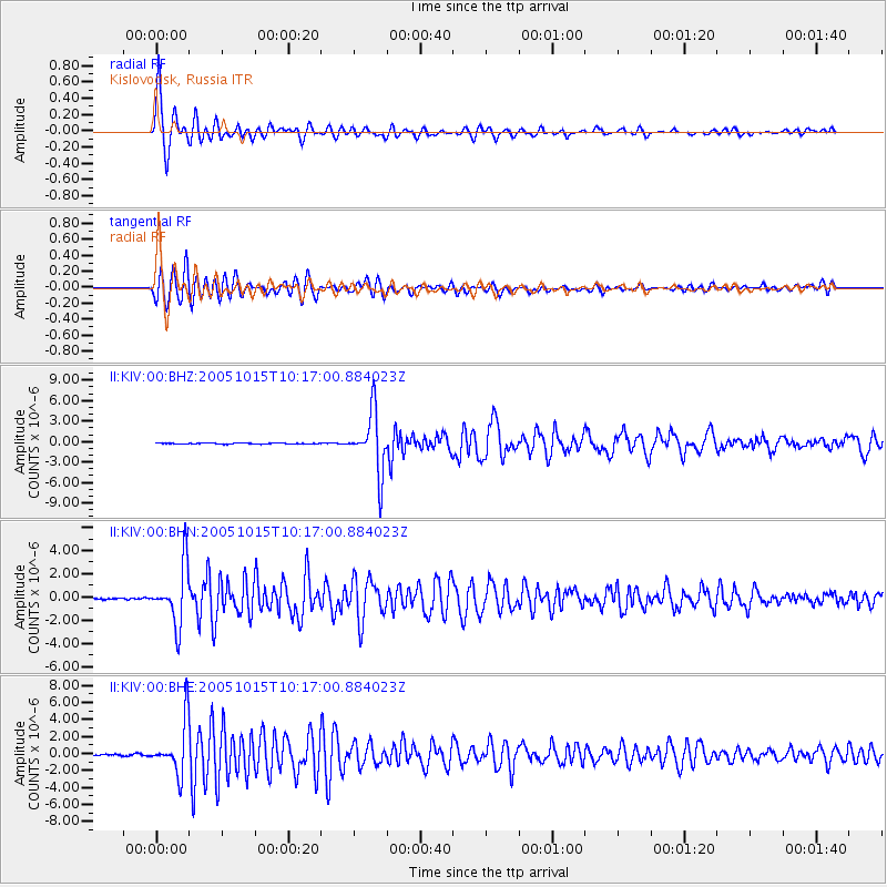
KIV Kislovodsk, Russia - Earthquake Result Viewer
| Earthquake location: |
East Of Kuril Islands |
| Earthquake latitude/longitude: |
46.8/154.1 |
| Earthquake time(UTC): |
2005/10/15 (288) 10:06:17 GMT |
| Earthquake Depth: |
43 km |
| Earthquake Magnitude: |
6.0 MB, 5.7 MS, 6.1 MW, 6.0 MW |
| Earthquake Catalog/Contributor: |
WHDF/NEIC |
|
| Network: |
II Global Seismograph Network (GSN - IRIS/IDA) |
| Station: |
KIV Kislovodsk, Russia |
| Lat/Lon: |
43.96 N/42.69 E |
| Elevation: |
1054 m |
|
| Distance: |
71.2 deg |
| Az: |
314.765 deg |
| Baz: |
42.468 deg |
| Ray Param: |
0.054381244 |
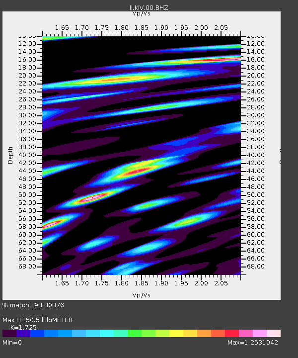
| Estimated Moho Depth: |
50.5 km |
| Estimated Crust Vp/Vs: |
1.73 |
| Assumed Crust Vp: |
6.247 km/s |
| Estimated Crust Vs: |
3.621 km/s |
| Estimated Crust Poisson's Ratio: |
0.25 |
|
| Radial Match: |
98.30876 % |
| Radial Bump: |
331 |
| Transverse Match: |
95.95341 % |
| Transverse Bump: |
400 |
| SOD ConfigId: |
2422 |
| Insert Time: |
2010-03-01 18:16:38.942 +0000 |
| GWidth: |
2.5 |
| Max Bumps: |
400 |
| Tol: |
0.001 |
|
Signal To Noise
| Channel | StoN | STA | LTA |
| II:KIV:00:BHN:20051015T10:17:00.884023Z | 37.094425 | 2.5286665E-6 | 6.816837E-8 |
| II:KIV:00:BHE:20051015T10:17:00.884023Z | 26.715082 | 3.0591452E-6 | 1.1451004E-7 |
| II:KIV:00:BHZ:20051015T10:17:00.884023Z | 57.448475 | 4.3809464E-6 | 7.625871E-8 |
| Arrivals |
| Ps | 6.1 SECOND |
| PpPs | 21 SECOND |
| PsPs/PpSs | 27 SECOND |


