You are here: Home > Network List > LD - Lamont-Doherty Cooperative Seismographic Network Stations List
> Station MVL Millersville University, PA > Earthquake Result Viewer
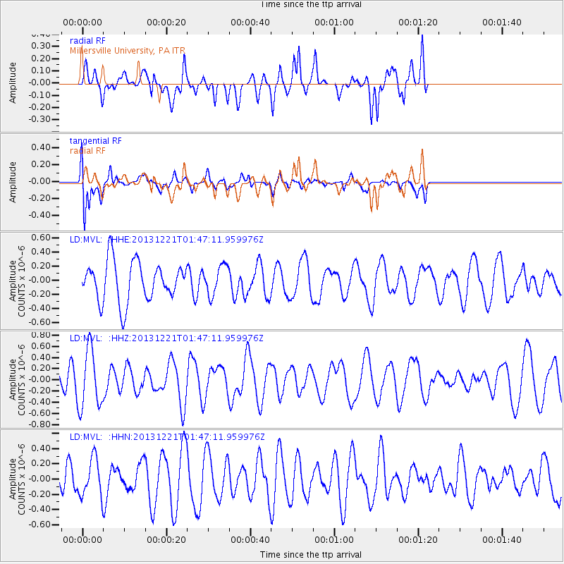
MVL Millersville University, PA - Earthquake Result Viewer
*The percent match for this event was below the threshold and hence no stack was calculated.
| Earthquake location: |
Near East Coast Of Honshu, Japan |
| Earthquake latitude/longitude: |
35.6/140.6 |
| Earthquake time(UTC): |
2013/12/21 (355) 01:34:13 GMT |
| Earthquake Depth: |
35 km |
| Earthquake Magnitude: |
5.5 MWB, 5.6 MWC |
| Earthquake Catalog/Contributor: |
NEIC PDE/NEIC COMCAT |
|
| Network: |
LD Lamont-Doherty Cooperative Seismographic Network |
| Station: |
MVL Millersville University, PA |
| Lat/Lon: |
40.00 N/76.35 W |
| Elevation: |
91 m |
|
| Distance: |
97.4 deg |
| Az: |
27.787 deg |
| Baz: |
330.361 deg |
| Ray Param: |
$rayparam |
*The percent match for this event was below the threshold and hence was not used in the summary stack. |
|
| Radial Match: |
54.859478 % |
| Radial Bump: |
400 |
| Transverse Match: |
54.248505 % |
| Transverse Bump: |
400 |
| SOD ConfigId: |
626651 |
| Insert Time: |
2014-04-20 02:34:05.795 +0000 |
| GWidth: |
2.5 |
| Max Bumps: |
400 |
| Tol: |
0.001 |
|
Signal To Noise
| Channel | StoN | STA | LTA |
| LD:MVL: :HHZ:20131221T01:47:11.959976Z | 3.3512306 | 5.312488E-7 | 1.585235E-7 |
| LD:MVL: :HHN:20131221T01:47:11.959976Z | 0.67154956 | 2.5034907E-7 | 3.7279312E-7 |
| LD:MVL: :HHE:20131221T01:47:11.959976Z | 0.74261147 | 2.0903182E-7 | 2.8148207E-7 |
| Arrivals |
| Ps | |
| PpPs | |
| PsPs/PpSs | |


