You are here: Home > Network List > TA - USArray Transportable Network (new EarthScope stations) Stations List
> Station E48A Lockeyer, ON, CAN > Earthquake Result Viewer
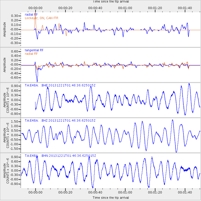
E48A Lockeyer, ON, CAN - Earthquake Result Viewer
*The percent match for this event was below the threshold and hence no stack was calculated.
| Earthquake location: |
Near East Coast Of Honshu, Japan |
| Earthquake latitude/longitude: |
35.6/140.6 |
| Earthquake time(UTC): |
2013/12/21 (355) 01:34:13 GMT |
| Earthquake Depth: |
35 km |
| Earthquake Magnitude: |
5.5 MWB, 5.6 MWC |
| Earthquake Catalog/Contributor: |
NEIC PDE/NEIC COMCAT |
|
| Network: |
TA USArray Transportable Network (new EarthScope stations) |
| Station: |
E48A Lockeyer, ON, CAN |
| Lat/Lon: |
46.48 N/82.17 W |
| Elevation: |
347 m |
|
| Distance: |
89.7 deg |
| Az: |
28.012 deg |
| Baz: |
326.37 deg |
| Ray Param: |
$rayparam |
*The percent match for this event was below the threshold and hence was not used in the summary stack. |
|
| Radial Match: |
38.987793 % |
| Radial Bump: |
400 |
| Transverse Match: |
86.16162 % |
| Transverse Bump: |
400 |
| SOD ConfigId: |
626651 |
| Insert Time: |
2014-04-20 02:39:12.424 +0000 |
| GWidth: |
2.5 |
| Max Bumps: |
400 |
| Tol: |
0.001 |
|
Signal To Noise
| Channel | StoN | STA | LTA |
| TA:E48A: :BHZ:20131221T01:46:36.625015Z | 0.9414544 | 4.7735085E-7 | 5.0703557E-7 |
| TA:E48A: :BHN:20131221T01:46:36.625015Z | 2.7966843 | 6.3564823E-7 | 2.2728639E-7 |
| TA:E48A: :BHE:20131221T01:46:36.625015Z | 0.6456036 | 2.4959365E-7 | 3.866051E-7 |
| Arrivals |
| Ps | |
| PpPs | |
| PsPs/PpSs | |


