You are here: Home > Network List > TA - USArray Transportable Network (new EarthScope stations) Stations List
> Station N61A South Mountain, Millburn, NJ, USA > Earthquake Result Viewer
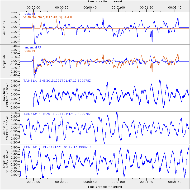
N61A South Mountain, Millburn, NJ, USA - Earthquake Result Viewer
*The percent match for this event was below the threshold and hence no stack was calculated.
| Earthquake location: |
Near East Coast Of Honshu, Japan |
| Earthquake latitude/longitude: |
35.6/140.6 |
| Earthquake time(UTC): |
2013/12/21 (355) 01:34:13 GMT |
| Earthquake Depth: |
35 km |
| Earthquake Magnitude: |
5.5 MWB, 5.6 MWC |
| Earthquake Catalog/Contributor: |
NEIC PDE/NEIC COMCAT |
|
| Network: |
TA USArray Transportable Network (new EarthScope stations) |
| Station: |
N61A South Mountain, Millburn, NJ, USA |
| Lat/Lon: |
40.75 N/74.30 W |
| Elevation: |
108 m |
|
| Distance: |
97.5 deg |
| Az: |
26.035 deg |
| Baz: |
331.914 deg |
| Ray Param: |
$rayparam |
*The percent match for this event was below the threshold and hence was not used in the summary stack. |
|
| Radial Match: |
54.372406 % |
| Radial Bump: |
400 |
| Transverse Match: |
76.37154 % |
| Transverse Bump: |
400 |
| SOD ConfigId: |
626651 |
| Insert Time: |
2014-04-20 02:42:24.066 +0000 |
| GWidth: |
2.5 |
| Max Bumps: |
400 |
| Tol: |
0.001 |
|
Signal To Noise
| Channel | StoN | STA | LTA |
| TA:N61A: :BHZ:20131221T01:47:12.399978Z | 0.7243391 | 2.911958E-7 | 4.0201584E-7 |
| TA:N61A: :BHN:20131221T01:47:12.399978Z | 1.1483885 | 4.5295658E-7 | 3.94428E-7 |
| TA:N61A: :BHE:20131221T01:47:12.399978Z | 0.89492255 | 2.2400576E-7 | 2.5030744E-7 |
| Arrivals |
| Ps | |
| PpPs | |
| PsPs/PpSs | |


