You are here: Home > Network List > TA - USArray Transportable Network (new EarthScope stations) Stations List
> Station TPFO Pinon Flats, CA, USA > Earthquake Result Viewer
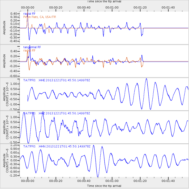
TPFO Pinon Flats, CA, USA - Earthquake Result Viewer
*The percent match for this event was below the threshold and hence no stack was calculated.
| Earthquake location: |
Near East Coast Of Honshu, Japan |
| Earthquake latitude/longitude: |
35.6/140.6 |
| Earthquake time(UTC): |
2013/12/21 (355) 01:34:13 GMT |
| Earthquake Depth: |
35 km |
| Earthquake Magnitude: |
5.5 MWB, 5.6 MWC |
| Earthquake Catalog/Contributor: |
NEIC PDE/NEIC COMCAT |
|
| Network: |
TA USArray Transportable Network (new EarthScope stations) |
| Station: |
TPFO Pinon Flats, CA, USA |
| Lat/Lon: |
33.61 N/116.45 W |
| Elevation: |
1275 m |
|
| Distance: |
80.4 deg |
| Az: |
55.607 deg |
| Baz: |
306.321 deg |
| Ray Param: |
$rayparam |
*The percent match for this event was below the threshold and hence was not used in the summary stack. |
|
| Radial Match: |
83.96042 % |
| Radial Bump: |
400 |
| Transverse Match: |
88.04305 % |
| Transverse Bump: |
362 |
| SOD ConfigId: |
626651 |
| Insert Time: |
2014-04-20 02:43:43.068 +0000 |
| GWidth: |
2.5 |
| Max Bumps: |
400 |
| Tol: |
0.001 |
|
Signal To Noise
| Channel | StoN | STA | LTA |
| TA:TPFO: :HHZ:20131221T01:45:50.149978Z | 1.7288198 | 1.0951436E-6 | 6.3346306E-7 |
| TA:TPFO: :HHN:20131221T01:45:50.149978Z | 1.2210779 | 4.874784E-7 | 3.9921974E-7 |
| TA:TPFO: :HHE:20131221T01:45:50.149978Z | 0.6167735 | 1.8425467E-7 | 2.9873962E-7 |
| Arrivals |
| Ps | |
| PpPs | |
| PsPs/PpSs | |


