You are here: Home > Network List > TA - USArray Transportable Network (new EarthScope stations) Stations List
> Station Y12C Blythe, CA, USA > Earthquake Result Viewer
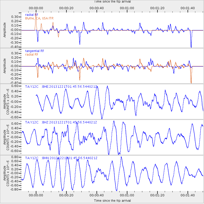
Y12C Blythe, CA, USA - Earthquake Result Viewer
*The percent match for this event was below the threshold and hence no stack was calculated.
| Earthquake location: |
Near East Coast Of Honshu, Japan |
| Earthquake latitude/longitude: |
35.6/140.6 |
| Earthquake time(UTC): |
2013/12/21 (355) 01:34:13 GMT |
| Earthquake Depth: |
35 km |
| Earthquake Magnitude: |
5.5 MWB, 5.6 MWC |
| Earthquake Catalog/Contributor: |
NEIC PDE/NEIC COMCAT |
|
| Network: |
TA USArray Transportable Network (new EarthScope stations) |
| Station: |
Y12C Blythe, CA, USA |
| Lat/Lon: |
33.75 N/114.52 W |
| Elevation: |
196 m |
|
| Distance: |
81.6 deg |
| Az: |
54.515 deg |
| Baz: |
307.215 deg |
| Ray Param: |
$rayparam |
*The percent match for this event was below the threshold and hence was not used in the summary stack. |
|
| Radial Match: |
39.76974 % |
| Radial Bump: |
255 |
| Transverse Match: |
37.236645 % |
| Transverse Bump: |
300 |
| SOD ConfigId: |
626651 |
| Insert Time: |
2014-04-20 02:44:00.769 +0000 |
| GWidth: |
2.5 |
| Max Bumps: |
400 |
| Tol: |
0.001 |
|
Signal To Noise
| Channel | StoN | STA | LTA |
| TA:Y12C: :BHZ:20131221T01:45:56.544021Z | 1.2929189 | 2.3424799E-7 | 1.8117763E-7 |
| TA:Y12C: :BHN:20131221T01:45:56.544021Z | 2.192498 | 4.494209E-7 | 2.0498122E-7 |
| TA:Y12C: :BHE:20131221T01:45:56.544021Z | 0.96913415 | 2.3160636E-7 | 2.3898278E-7 |
| Arrivals |
| Ps | |
| PpPs | |
| PsPs/PpSs | |


