You are here: Home > Network List > II - Global Seismograph Network (GSN - IRIS/IDA) Stations List
> Station WRAB Tennant Creek, NT, Australia > Earthquake Result Viewer
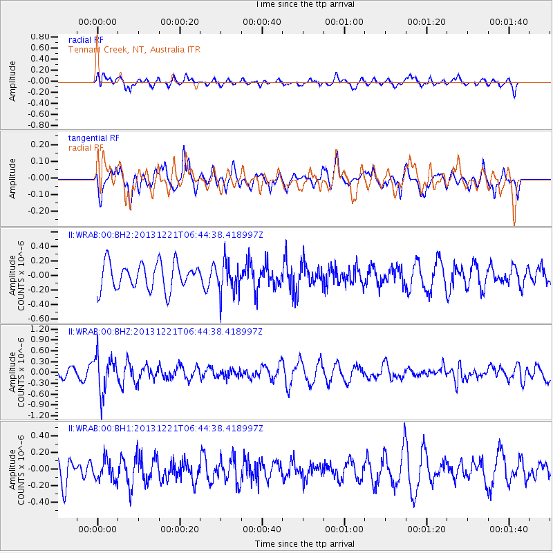
WRAB Tennant Creek, NT, Australia - Earthquake Result Viewer
*The percent match for this event was below the threshold and hence no stack was calculated.
| Earthquake location: |
Southeast Of Loyalty Islands |
| Earthquake latitude/longitude: |
-22.3/171.7 |
| Earthquake time(UTC): |
2013/12/21 (355) 06:38:29 GMT |
| Earthquake Depth: |
122 km |
| Earthquake Magnitude: |
5.5 MWB |
| Earthquake Catalog/Contributor: |
NEIC PDE/NEIC COMCAT |
|
| Network: |
II Global Seismograph Network (GSN - IRIS/IDA) |
| Station: |
WRAB Tennant Creek, NT, Australia |
| Lat/Lon: |
19.93 S/134.36 E |
| Elevation: |
366 m |
|
| Distance: |
34.9 deg |
| Az: |
266.786 deg |
| Baz: |
100.596 deg |
| Ray Param: |
$rayparam |
*The percent match for this event was below the threshold and hence was not used in the summary stack. |
|
| Radial Match: |
54.85025 % |
| Radial Bump: |
400 |
| Transverse Match: |
59.32305 % |
| Transverse Bump: |
400 |
| SOD ConfigId: |
626651 |
| Insert Time: |
2014-04-20 02:53:26.931 +0000 |
| GWidth: |
2.5 |
| Max Bumps: |
400 |
| Tol: |
0.001 |
|
Signal To Noise
| Channel | StoN | STA | LTA |
| II:WRAB:00:BHZ:20131221T06:44:38.418997Z | 2.888534 | 5.0200697E-7 | 1.7379297E-7 |
| II:WRAB:00:BH1:20131221T06:44:38.418997Z | 0.9386762 | 1.2525562E-7 | 1.3343859E-7 |
| II:WRAB:00:BH2:20131221T06:44:38.418997Z | 1.214332 | 2.2036919E-7 | 1.814736E-7 |
| Arrivals |
| Ps | |
| PpPs | |
| PsPs/PpSs | |


