You are here: Home > Network List > IU - Global Seismograph Network (GSN - IRIS/USGS) Stations List
> Station CTAO Charters Towers, Australia > Earthquake Result Viewer
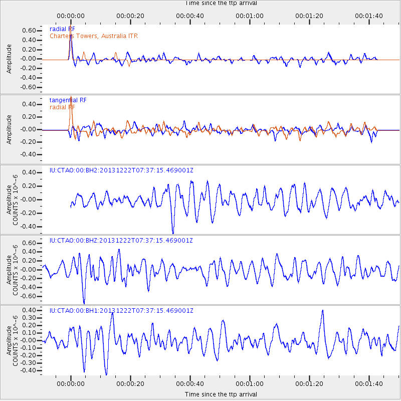
CTAO Charters Towers, Australia - Earthquake Result Viewer
*The percent match for this event was below the threshold and hence no stack was calculated.
| Earthquake location: |
Southeast Indian Ridge |
| Earthquake latitude/longitude: |
-46.4/96.1 |
| Earthquake time(UTC): |
2013/12/22 (356) 07:29:03 GMT |
| Earthquake Depth: |
9.9 km |
| Earthquake Magnitude: |
5.5 MWB, 5.6 MWC |
| Earthquake Catalog/Contributor: |
NEIC PDE/NEIC COMCAT |
|
| Network: |
IU Global Seismograph Network (GSN - IRIS/USGS) |
| Station: |
CTAO Charters Towers, Australia |
| Lat/Lon: |
20.09 S/146.25 E |
| Elevation: |
357 m |
|
| Distance: |
48.4 deg |
| Az: |
74.554 deg |
| Baz: |
225.159 deg |
| Ray Param: |
$rayparam |
*The percent match for this event was below the threshold and hence was not used in the summary stack. |
|
| Radial Match: |
53.19738 % |
| Radial Bump: |
381 |
| Transverse Match: |
46.79778 % |
| Transverse Bump: |
400 |
| SOD ConfigId: |
626651 |
| Insert Time: |
2014-04-20 03:01:20.380 +0000 |
| GWidth: |
2.5 |
| Max Bumps: |
400 |
| Tol: |
0.001 |
|
Signal To Noise
| Channel | StoN | STA | LTA |
| IU:CTAO:00:BHZ:20131222T07:37:15.469001Z | 2.6678805 | 3.0886486E-7 | 1.1577162E-7 |
| IU:CTAO:00:BH1:20131222T07:37:15.469001Z | 1.6712124 | 1.7813502E-7 | 1.0659029E-7 |
| IU:CTAO:00:BH2:20131222T07:37:15.469001Z | 3.341991 | 2.0216791E-7 | 6.049326E-8 |
| Arrivals |
| Ps | |
| PpPs | |
| PsPs/PpSs | |


