You are here: Home > Network List > NI - North-East Italy Broadband Network Stations List
> Station CGRP Cima Grappa > Earthquake Result Viewer
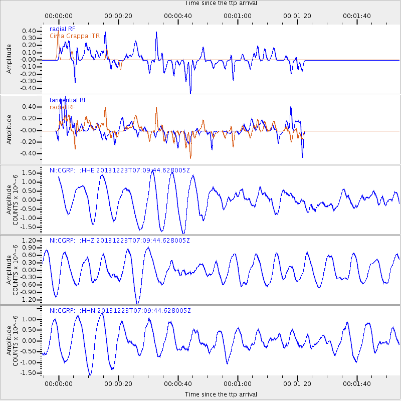
CGRP Cima Grappa - Earthquake Result Viewer
*The percent match for this event was below the threshold and hence no stack was calculated.
| Earthquake location: |
Off East Coast Of Honshu, Japan |
| Earthquake latitude/longitude: |
35.7/142.1 |
| Earthquake time(UTC): |
2013/12/23 (357) 06:57:29 GMT |
| Earthquake Depth: |
8.0 km |
| Earthquake Magnitude: |
5.6 MWB, 5.6 MWC |
| Earthquake Catalog/Contributor: |
NEIC PDE/NEIC COMCAT |
|
| Network: |
NI North-East Italy Broadband Network |
| Station: |
CGRP Cima Grappa |
| Lat/Lon: |
45.88 N/11.80 E |
| Elevation: |
1757 m |
|
| Distance: |
87.3 deg |
| Az: |
327.786 deg |
| Baz: |
38.406 deg |
| Ray Param: |
$rayparam |
*The percent match for this event was below the threshold and hence was not used in the summary stack. |
|
| Radial Match: |
69.02997 % |
| Radial Bump: |
400 |
| Transverse Match: |
49.80653 % |
| Transverse Bump: |
400 |
| SOD ConfigId: |
626651 |
| Insert Time: |
2014-04-20 03:20:54.410 +0000 |
| GWidth: |
2.5 |
| Max Bumps: |
400 |
| Tol: |
0.001 |
|
Signal To Noise
| Channel | StoN | STA | LTA |
| NI:CGRP: :HHZ:20131223T07:09:44.628005Z | 1.3144126 | 5.89172E-7 | 4.4823972E-7 |
| NI:CGRP: :HHN:20131223T07:09:44.628005Z | 1.4999497 | 6.8357446E-7 | 4.557316E-7 |
| NI:CGRP: :HHE:20131223T07:09:44.628005Z | 1.5625796 | 1.1210531E-6 | 7.174374E-7 |
| Arrivals |
| Ps | |
| PpPs | |
| PsPs/PpSs | |


