You are here: Home > Network List > TA - USArray Transportable Network (new EarthScope stations) Stations List
> Station F61A St Evariste, QC, CAN > Earthquake Result Viewer
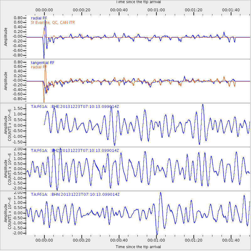
F61A St Evariste, QC, CAN - Earthquake Result Viewer
*The percent match for this event was below the threshold and hence no stack was calculated.
| Earthquake location: |
Off East Coast Of Honshu, Japan |
| Earthquake latitude/longitude: |
35.7/142.1 |
| Earthquake time(UTC): |
2013/12/23 (357) 06:57:29 GMT |
| Earthquake Depth: |
8.0 km |
| Earthquake Magnitude: |
5.6 MWB, 5.6 MWC |
| Earthquake Catalog/Contributor: |
NEIC PDE/NEIC COMCAT |
|
| Network: |
TA USArray Transportable Network (new EarthScope stations) |
| Station: |
F61A St Evariste, QC, CAN |
| Lat/Lon: |
45.97 N/70.99 W |
| Elevation: |
350 m |
|
| Distance: |
93.4 deg |
| Az: |
22.448 deg |
| Baz: |
333.53 deg |
| Ray Param: |
$rayparam |
*The percent match for this event was below the threshold and hence was not used in the summary stack. |
|
| Radial Match: |
68.05244 % |
| Radial Bump: |
400 |
| Transverse Match: |
61.550686 % |
| Transverse Bump: |
400 |
| SOD ConfigId: |
626651 |
| Insert Time: |
2014-04-20 03:25:10.682 +0000 |
| GWidth: |
2.5 |
| Max Bumps: |
400 |
| Tol: |
0.001 |
|
Signal To Noise
| Channel | StoN | STA | LTA |
| TA:F61A: :BHZ:20131223T07:10:13.099014Z | 1.1142306 | 9.560324E-7 | 8.580202E-7 |
| TA:F61A: :BHN:20131223T07:10:13.099014Z | 1.0184758 | 8.427513E-7 | 8.274633E-7 |
| TA:F61A: :BHE:20131223T07:10:13.099014Z | 1.3473274 | 7.7588606E-7 | 5.758705E-7 |
| Arrivals |
| Ps | |
| PpPs | |
| PsPs/PpSs | |


