You are here: Home > Network List > AZ - ANZA Regional Network Stations List
> Station SMER AZ.SMER > Earthquake Result Viewer
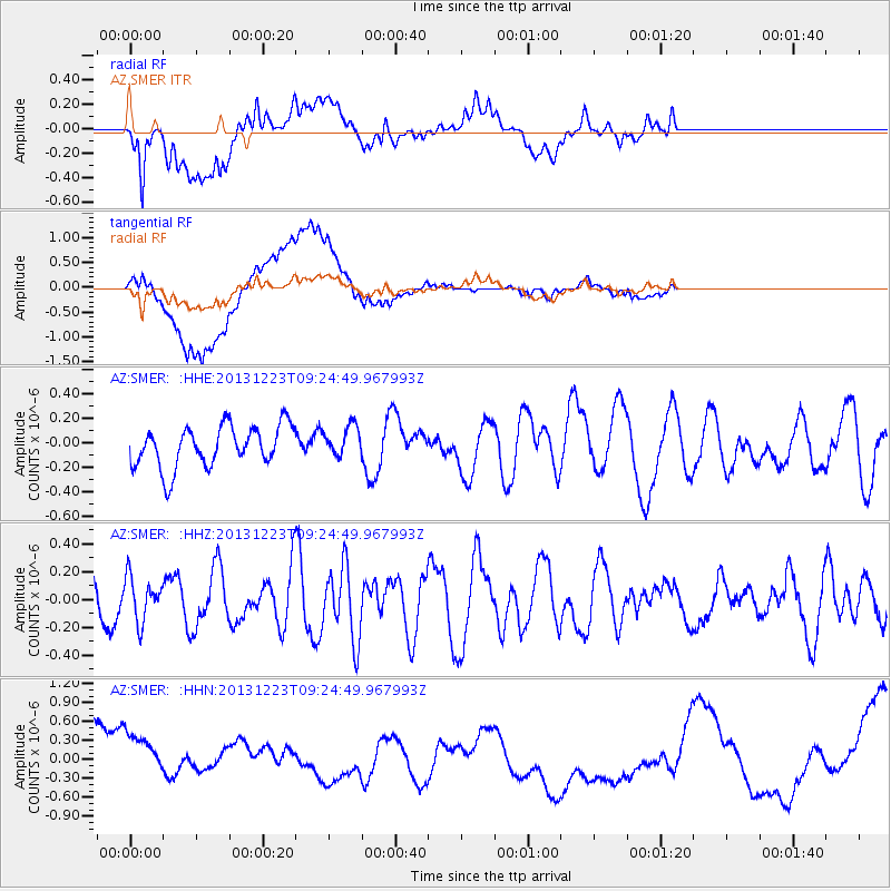
SMER AZ.SMER - Earthquake Result Viewer
*The percent match for this event was below the threshold and hence no stack was calculated.
| Earthquake location: |
South Of Mariana Islands |
| Earthquake latitude/longitude: |
12.8/143.0 |
| Earthquake time(UTC): |
2013/12/23 (357) 09:12:27 GMT |
| Earthquake Depth: |
92 km |
| Earthquake Magnitude: |
5.8 MWW, 5.9 MWC, 5.9 MWB |
| Earthquake Catalog/Contributor: |
NEIC PDE/NEIC COMCAT |
|
| Network: |
AZ ANZA Regional Network |
| Station: |
SMER AZ.SMER |
| Lat/Lon: |
33.46 N/117.17 W |
| Elevation: |
355 m |
|
| Distance: |
91.0 deg |
| Az: |
55.482 deg |
| Baz: |
285.946 deg |
| Ray Param: |
$rayparam |
*The percent match for this event was below the threshold and hence was not used in the summary stack. |
|
| Radial Match: |
55.825367 % |
| Radial Bump: |
400 |
| Transverse Match: |
41.77682 % |
| Transverse Bump: |
400 |
| SOD ConfigId: |
626651 |
| Insert Time: |
2014-04-20 03:36:20.939 +0000 |
| GWidth: |
2.5 |
| Max Bumps: |
400 |
| Tol: |
0.001 |
|
Signal To Noise
| Channel | StoN | STA | LTA |
| AZ:SMER: :HHZ:20131223T09:24:49.967993Z | 0.7775111 | 1.569192E-7 | 2.0182244E-7 |
| AZ:SMER: :HHN:20131223T09:24:49.967993Z | 1.0408473 | 5.47061E-7 | 5.25592E-7 |
| AZ:SMER: :HHE:20131223T09:24:49.967993Z | 0.7512652 | 1.255458E-7 | 1.6711249E-7 |
| Arrivals |
| Ps | |
| PpPs | |
| PsPs/PpSs | |


