You are here: Home > Network List > BK - Berkeley Digital Seismograph Network Stations List
> Station HUMO Hull Mountain, OR > Earthquake Result Viewer
HUMO Hull Mountain, OR - Earthquake Result Viewer
*The percent match for this event was below the threshold and hence no stack was calculated.
| Earthquake location: |
South Of Mariana Islands |
| Earthquake latitude/longitude: |
12.8/143.0 |
| Earthquake time(UTC): |
2013/12/23 (357) 09:12:27 GMT |
| Earthquake Depth: |
92 km |
| Earthquake Magnitude: |
5.8 MWW, 5.9 MWC, 5.9 MWB |
| Earthquake Catalog/Contributor: |
NEIC PDE/NEIC COMCAT |
|
| Network: |
BK Berkeley Digital Seismograph Network |
| Station: |
HUMO Hull Mountain, OR |
| Lat/Lon: |
42.61 N/122.96 W |
| Elevation: |
555 m |
|
| Distance: |
84.4 deg |
| Az: |
47.733 deg |
| Baz: |
282.073 deg |
| Ray Param: |
$rayparam |
*The percent match for this event was below the threshold and hence was not used in the summary stack. |
|
| Radial Match: |
67.26441 % |
| Radial Bump: |
400 |
| Transverse Match: |
69.24605 % |
| Transverse Bump: |
347 |
| SOD ConfigId: |
626651 |
| Insert Time: |
2014-04-20 03:36:39.319 +0000 |
| GWidth: |
2.5 |
| Max Bumps: |
400 |
| Tol: |
0.001 |
|
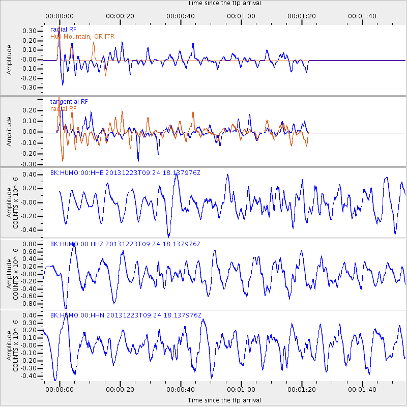
Signal To Noise
| Channel | StoN | STA | LTA |
| BK:HUMO:00:HHZ:20131223T09:24:18.137976Z | 1.6439751 | 5.076787E-7 | 3.0881165E-7 |
| BK:HUMO:00:HHN:20131223T09:24:18.137976Z | 1.6560475 | 2.875381E-7 | 1.7362915E-7 |
| BK:HUMO:00:HHE:20131223T09:24:18.137976Z | 0.90670824 | 1.3340616E-7 | 1.471324E-7 |
| Arrivals |
| Ps | |
| PpPs | |
| PsPs/PpSs | |


