You are here: Home > Network List > YB13 - Continental Dynamics/Cent. Anatolian Tectonics:Surface to Mantle Dynamics During Stations List
> Station AT30 Akpinar,Aksaray,Turkey > Earthquake Result Viewer
AT30 Akpinar,Aksaray,Turkey - Earthquake Result Viewer
| Earthquake location: |
Near East Coast Of Honshu, Japan |
| Earthquake latitude/longitude: |
37.4/141.5 |
| Earthquake time(UTC): |
2014/12/20 (354) 09:29:58 GMT |
| Earthquake Depth: |
37 km |
| Earthquake Magnitude: |
5.9 MB |
| Earthquake Catalog/Contributor: |
NEIC PDE/NEIC COMCAT |
|
| Network: |
YB Continental Dynamics/Cent. Anatolian Tectonics:Surface to Mantle Dynamics During |
| Station: |
AT30 Akpinar,Aksaray,Turkey |
| Lat/Lon: |
38.76 N/34.00 E |
| Elevation: |
1404 m |
|
| Distance: |
79.1 deg |
| Az: |
310.61 deg |
| Baz: |
50.658 deg |
| Ray Param: |
0.049150735 |
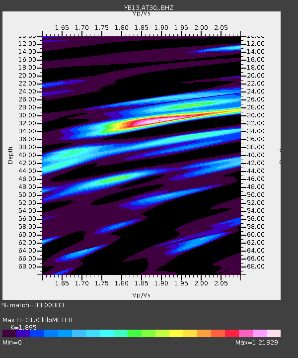
| Estimated Moho Depth: |
31.0 km |
| Estimated Crust Vp/Vs: |
1.89 |
| Assumed Crust Vp: |
6.35 km/s |
| Estimated Crust Vs: |
3.351 km/s |
| Estimated Crust Poisson's Ratio: |
0.31 |
|
| Radial Match: |
88.00883 % |
| Radial Bump: |
400 |
| Transverse Match: |
75.19259 % |
| Transverse Bump: |
400 |
| SOD ConfigId: |
3390531 |
| Insert Time: |
2019-04-15 17:06:02.657 +0000 |
| GWidth: |
2.5 |
| Max Bumps: |
400 |
| Tol: |
0.001 |
|

Signal To Noise
| Channel | StoN | STA | LTA |
| YB:AT30: :BHZ:20141220T09:41:27.620005Z | 18.538738 | 8.7036716E-7 | 4.6948564E-8 |
| YB:AT30: :BHN:20141220T09:41:27.620005Z | 5.323326 | 3.1029913E-7 | 5.8290464E-8 |
| YB:AT30: :BHE:20141220T09:41:27.620005Z | 5.409016 | 3.1184265E-7 | 5.765238E-8 |
| Arrivals |
| Ps | 4.5 SECOND |
| PpPs | 14 SECOND |
| PsPs/PpSs | 18 SECOND |


