You are here: Home > Network List > TA - USArray Transportable Network (new EarthScope stations) Stations List
> Station O03E Paynes Creek, CA, USA > Earthquake Result Viewer
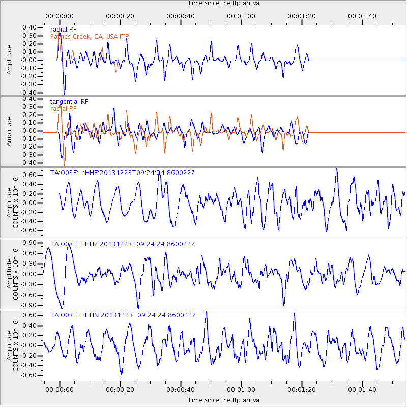
O03E Paynes Creek, CA, USA - Earthquake Result Viewer
*The percent match for this event was below the threshold and hence no stack was calculated.
| Earthquake location: |
South Of Mariana Islands |
| Earthquake latitude/longitude: |
12.8/143.0 |
| Earthquake time(UTC): |
2013/12/23 (357) 09:12:27 GMT |
| Earthquake Depth: |
92 km |
| Earthquake Magnitude: |
5.8 MWW, 5.9 MWC, 5.9 MWB |
| Earthquake Catalog/Contributor: |
NEIC PDE/NEIC COMCAT |
|
| Network: |
TA USArray Transportable Network (new EarthScope stations) |
| Station: |
O03E Paynes Creek, CA, USA |
| Lat/Lon: |
40.29 N/121.80 W |
| Elevation: |
967 m |
|
| Distance: |
85.7 deg |
| Az: |
49.807 deg |
| Baz: |
283.013 deg |
| Ray Param: |
$rayparam |
*The percent match for this event was below the threshold and hence was not used in the summary stack. |
|
| Radial Match: |
72.91842 % |
| Radial Bump: |
400 |
| Transverse Match: |
69.0595 % |
| Transverse Bump: |
400 |
| SOD ConfigId: |
626651 |
| Insert Time: |
2014-04-20 03:46:14.490 +0000 |
| GWidth: |
2.5 |
| Max Bumps: |
400 |
| Tol: |
0.001 |
|
Signal To Noise
| Channel | StoN | STA | LTA |
| TA:O03E: :HHZ:20131223T09:24:24.860022Z | 1.7482852 | 7.028205E-7 | 4.0200564E-7 |
| TA:O03E: :HHN:20131223T09:24:24.860022Z | 1.6355848 | 2.454817E-7 | 1.5008803E-7 |
| TA:O03E: :HHE:20131223T09:24:24.860022Z | 1.4782977 | 3.3979882E-7 | 2.2985817E-7 |
| Arrivals |
| Ps | |
| PpPs | |
| PsPs/PpSs | |


