You are here: Home > Network List > YB13 - Continental Dynamics/Cent. Anatolian Tectonics:Surface to Mantle Dynamics During Stations List
> Station AT40 Beyliova,Konya,Turkey > Earthquake Result Viewer
AT40 Beyliova,Konya,Turkey - Earthquake Result Viewer
| Earthquake location: |
Near East Coast Of Honshu, Japan |
| Earthquake latitude/longitude: |
37.4/141.5 |
| Earthquake time(UTC): |
2014/12/20 (354) 09:29:58 GMT |
| Earthquake Depth: |
37 km |
| Earthquake Magnitude: |
5.9 MB |
| Earthquake Catalog/Contributor: |
NEIC PDE/NEIC COMCAT |
|
| Network: |
YB Continental Dynamics/Cent. Anatolian Tectonics:Surface to Mantle Dynamics During |
| Station: |
AT40 Beyliova,Konya,Turkey |
| Lat/Lon: |
38.85 N/32.45 E |
| Elevation: |
1139 m |
|
| Distance: |
80.0 deg |
| Az: |
311.465 deg |
| Baz: |
49.844 deg |
| Ray Param: |
0.048549455 |
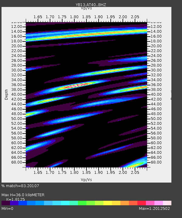
| Estimated Moho Depth: |
36.0 km |
| Estimated Crust Vp/Vs: |
1.81 |
| Assumed Crust Vp: |
6.159 km/s |
| Estimated Crust Vs: |
3.398 km/s |
| Estimated Crust Poisson's Ratio: |
0.28 |
|
| Radial Match: |
83.20107 % |
| Radial Bump: |
400 |
| Transverse Match: |
70.48987 % |
| Transverse Bump: |
400 |
| SOD ConfigId: |
3390531 |
| Insert Time: |
2019-04-15 17:06:07.743 +0000 |
| GWidth: |
2.5 |
| Max Bumps: |
400 |
| Tol: |
0.001 |
|

Signal To Noise
| Channel | StoN | STA | LTA |
| YB:AT40: :BHZ:20141220T09:41:32.378977Z | 11.706429 | 8.3405763E-7 | 7.124783E-8 |
| YB:AT40: :BHN:20141220T09:41:32.378977Z | 4.1176896 | 2.9325773E-7 | 7.1219006E-8 |
| YB:AT40: :BHE:20141220T09:41:32.378977Z | 2.850181 | 2.466661E-7 | 8.654401E-8 |
| Arrivals |
| Ps | 4.9 SECOND |
| PpPs | 16 SECOND |
| PsPs/PpSs | 21 SECOND |


