You are here: Home > Network List > UW - Pacific Northwest Regional Seismic Network Stations List
> Station YACT Amboy, WA, USA > Earthquake Result Viewer
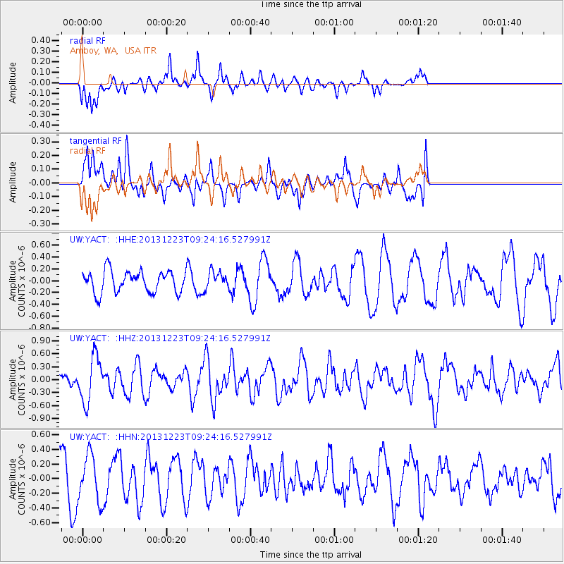
YACT Amboy, WA, USA - Earthquake Result Viewer
*The percent match for this event was below the threshold and hence no stack was calculated.
| Earthquake location: |
South Of Mariana Islands |
| Earthquake latitude/longitude: |
12.8/143.0 |
| Earthquake time(UTC): |
2013/12/23 (357) 09:12:27 GMT |
| Earthquake Depth: |
92 km |
| Earthquake Magnitude: |
5.8 MWW, 5.9 MWC, 5.9 MWB |
| Earthquake Catalog/Contributor: |
NEIC PDE/NEIC COMCAT |
|
| Network: |
UW Pacific Northwest Regional Seismic Network |
| Station: |
YACT Amboy, WA, USA |
| Lat/Lon: |
45.93 N/122.42 W |
| Elevation: |
211 m |
|
| Distance: |
84.1 deg |
| Az: |
44.384 deg |
| Baz: |
282.11 deg |
| Ray Param: |
$rayparam |
*The percent match for this event was below the threshold and hence was not used in the summary stack. |
|
| Radial Match: |
44.82517 % |
| Radial Bump: |
323 |
| Transverse Match: |
59.909683 % |
| Transverse Bump: |
400 |
| SOD ConfigId: |
626651 |
| Insert Time: |
2014-04-20 03:48:07.472 +0000 |
| GWidth: |
2.5 |
| Max Bumps: |
400 |
| Tol: |
0.001 |
|
Signal To Noise
| Channel | StoN | STA | LTA |
| UW:YACT: :HHZ:20131223T09:24:16.527991Z | 2.4017987 | 5.4030244E-7 | 2.2495742E-7 |
| UW:YACT: :HHN:20131223T09:24:16.527991Z | 1.2149467 | 3.1632172E-7 | 2.6035852E-7 |
| UW:YACT: :HHE:20131223T09:24:16.527991Z | 0.7851889 | 1.4218737E-7 | 1.8108685E-7 |
| Arrivals |
| Ps | |
| PpPs | |
| PsPs/PpSs | |


