You are here: Home > Network List > CI - Caltech Regional Seismic Network Stations List
> Station CIA CIA, Avalon Catalina Island, CA, USA > Earthquake Result Viewer
CIA CIA, Avalon Catalina Island, CA, USA - Earthquake Result Viewer

| Earthquake location: |
Tonga Islands |
| Earthquake latitude/longitude: |
-17.2/-173.9 |
| Earthquake time(UTC): |
2000/09/26 (270) 06:17:52 GMT |
| Earthquake Depth: |
56 km |
| Earthquake Magnitude: |
6.1 MB, 6.1 MS, 6.4 MW, 6.1 ME |
| Earthquake Catalog/Contributor: |
WHDF/NEIC |
|
| Network: |
CI Caltech Regional Seismic Network |
| Station: |
CIA CIA, Avalon Catalina Island, CA, USA |
| Lat/Lon: |
33.40 N/118.41 W |
| Elevation: |
467 m |
|
| Distance: |
73.0 deg |
| Az: |
46.13 deg |
| Baz: |
235.471 deg |
| Ray Param: |
0.05316364 |
| Estimated Moho Depth: |
15.25 km |
| Estimated Crust Vp/Vs: |
1.99 |
| Assumed Crust Vp: |
6.048 km/s |
| Estimated Crust Vs: |
3.047 km/s |
| Estimated Crust Poisson's Ratio: |
0.33 |
|
| Radial Match: |
89.01871 % |
| Radial Bump: |
400 |
| Transverse Match: |
89.33086 % |
| Transverse Bump: |
400 |
| SOD ConfigId: |
3787 |
| Insert Time: |
2010-02-25 20:54:53.605 +0000 |
| GWidth: |
2.5 |
| Max Bumps: |
400 |
| Tol: |
0.001 |
|
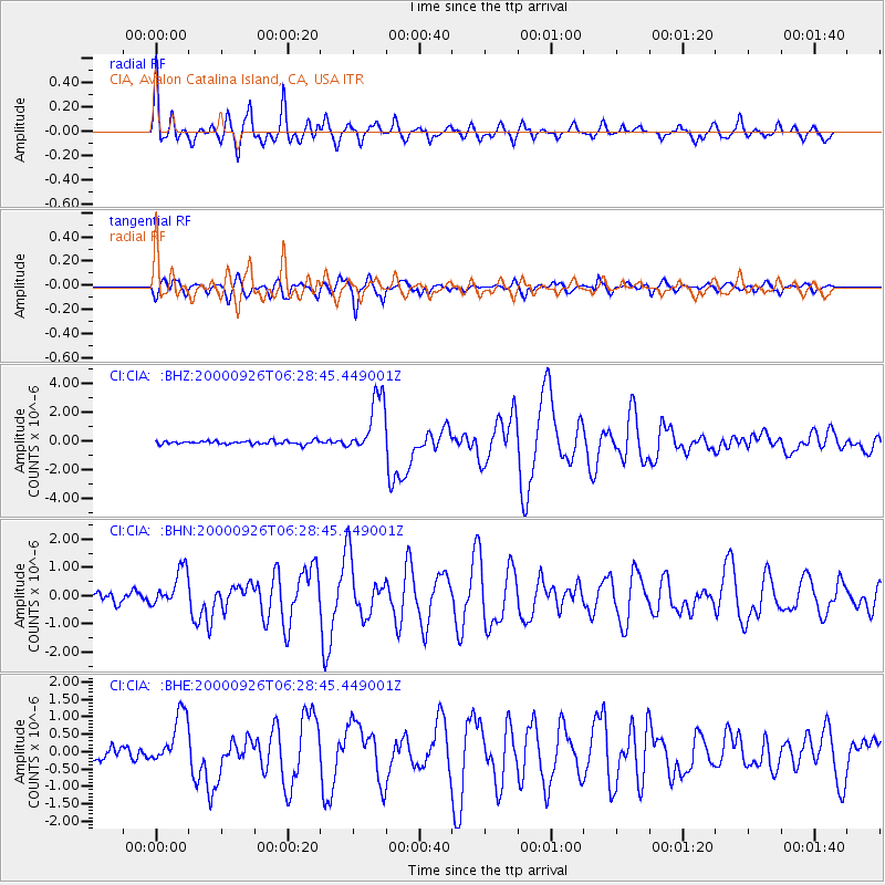
Signal To Noise
| Channel | StoN | STA | LTA |
| CI:CIA: :BHN:20000926T06:28:45.449001Z | 3.0069993 | 6.6275646E-7 | 2.204046E-7 |
| CI:CIA: :BHE:20000926T06:28:45.449001Z | 3.643256 | 7.5342604E-7 | 2.068002E-7 |
| CI:CIA: :BHZ:20000926T06:28:45.449001Z | 17.00229 | 2.0704556E-6 | 1.2177509E-7 |
| Arrivals |
| Ps | 2.6 SECOND |
| PpPs | 7.3 SECOND |
| PsPs/PpSs | 9.9 SECOND |


