You are here: Home > Network List > TA - USArray Transportable Network (new EarthScope stations) Stations List
> Station G59A Clarenceville, QC, USA > Earthquake Result Viewer
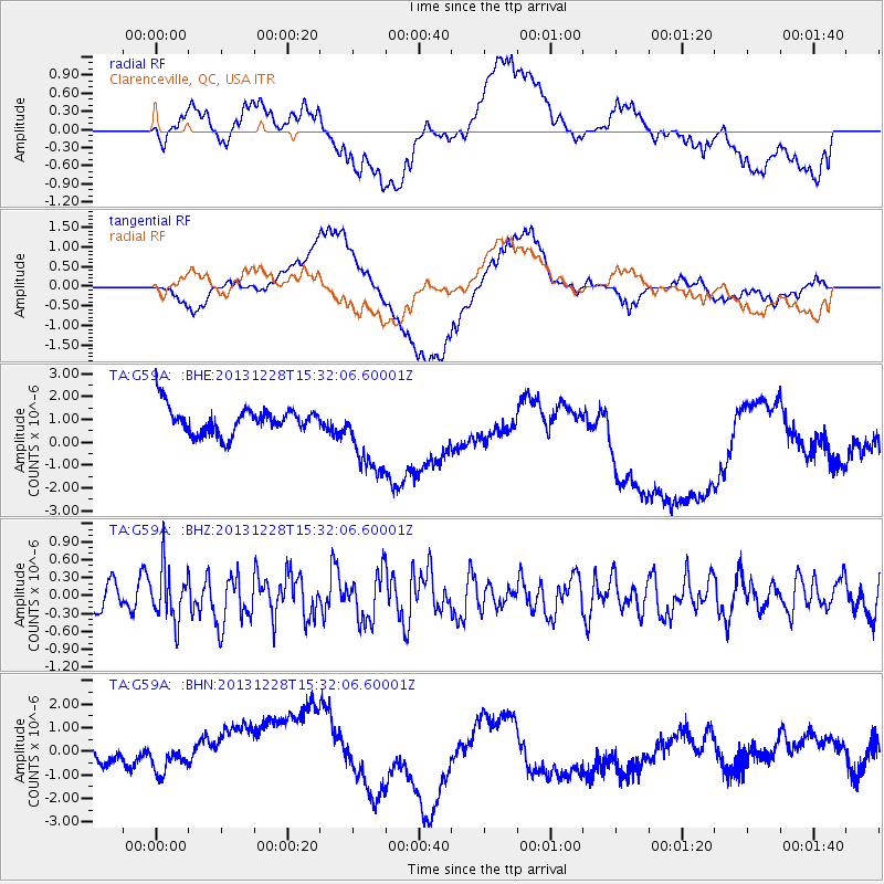
G59A Clarenceville, QC, USA - Earthquake Result Viewer
*The percent match for this event was below the threshold and hence no stack was calculated.
| Earthquake location: |
Turkey |
| Earthquake latitude/longitude: |
36.0/31.3 |
| Earthquake time(UTC): |
2013/12/28 (362) 15:21:04 GMT |
| Earthquake Depth: |
41 km |
| Earthquake Magnitude: |
5.9 MWW, 5.9 MWB, 6.0 MWC |
| Earthquake Catalog/Contributor: |
NEIC PDE/NEIC COMCAT |
|
| Network: |
TA USArray Transportable Network (new EarthScope stations) |
| Station: |
G59A Clarenceville, QC, USA |
| Lat/Lon: |
45.08 N/73.18 W |
| Elevation: |
36 m |
|
| Distance: |
74.4 deg |
| Az: |
314.576 deg |
| Baz: |
54.586 deg |
| Ray Param: |
$rayparam |
*The percent match for this event was below the threshold and hence was not used in the summary stack. |
|
| Radial Match: |
30.482374 % |
| Radial Bump: |
400 |
| Transverse Match: |
57.697315 % |
| Transverse Bump: |
400 |
| SOD ConfigId: |
626651 |
| Insert Time: |
2014-04-20 04:18:04.451 +0000 |
| GWidth: |
2.5 |
| Max Bumps: |
400 |
| Tol: |
0.001 |
|
Signal To Noise
| Channel | StoN | STA | LTA |
| TA:G59A: :BHZ:20131228T15:32:06.60001Z | 1.391033 | 4.3577688E-7 | 3.132757E-7 |
| TA:G59A: :BHN:20131228T15:32:06.60001Z | 0.6155217 | 4.918112E-7 | 7.9901514E-7 |
| TA:G59A: :BHE:20131228T15:32:06.60001Z | 2.9903872 | 1.7417506E-6 | 5.8244984E-7 |
| Arrivals |
| Ps | |
| PpPs | |
| PsPs/PpSs | |


