You are here: Home > Network List > TA - USArray Transportable Network (new EarthScope stations) Stations List
> Station H47A Mio, MI, USA > Earthquake Result Viewer
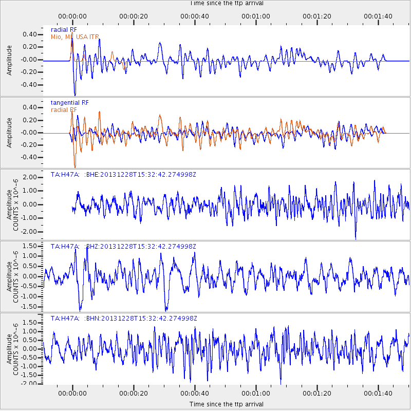
H47A Mio, MI, USA - Earthquake Result Viewer
*The percent match for this event was below the threshold and hence no stack was calculated.
| Earthquake location: |
Turkey |
| Earthquake latitude/longitude: |
36.0/31.3 |
| Earthquake time(UTC): |
2013/12/28 (362) 15:21:04 GMT |
| Earthquake Depth: |
41 km |
| Earthquake Magnitude: |
5.9 MWW, 5.9 MWB, 6.0 MWC |
| Earthquake Catalog/Contributor: |
NEIC PDE/NEIC COMCAT |
|
| Network: |
TA USArray Transportable Network (new EarthScope stations) |
| Station: |
H47A Mio, MI, USA |
| Lat/Lon: |
44.60 N/84.21 W |
| Elevation: |
356 m |
|
| Distance: |
80.8 deg |
| Az: |
319.22 deg |
| Baz: |
47.827 deg |
| Ray Param: |
$rayparam |
*The percent match for this event was below the threshold and hence was not used in the summary stack. |
|
| Radial Match: |
67.758194 % |
| Radial Bump: |
400 |
| Transverse Match: |
41.637985 % |
| Transverse Bump: |
400 |
| SOD ConfigId: |
626651 |
| Insert Time: |
2014-04-20 04:18:25.482 +0000 |
| GWidth: |
2.5 |
| Max Bumps: |
400 |
| Tol: |
0.001 |
|
Signal To Noise
| Channel | StoN | STA | LTA |
| TA:H47A: :BHZ:20131228T15:32:42.274998Z | 2.1130877 | 9.3281017E-7 | 4.4144414E-7 |
| TA:H47A: :BHN:20131228T15:32:42.274998Z | 0.58251375 | 3.5035734E-7 | 6.0145766E-7 |
| TA:H47A: :BHE:20131228T15:32:42.274998Z | 1.1979612 | 5.508026E-7 | 4.5978334E-7 |
| Arrivals |
| Ps | |
| PpPs | |
| PsPs/PpSs | |


