You are here: Home > Network List > TA - USArray Transportable Network (new EarthScope stations) Stations List
> Station I45A Fountain, MI, USA > Earthquake Result Viewer
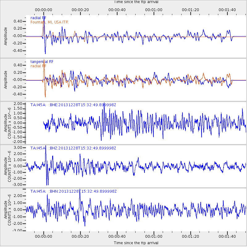
I45A Fountain, MI, USA - Earthquake Result Viewer
*The percent match for this event was below the threshold and hence no stack was calculated.
| Earthquake location: |
Turkey |
| Earthquake latitude/longitude: |
36.0/31.3 |
| Earthquake time(UTC): |
2013/12/28 (362) 15:21:04 GMT |
| Earthquake Depth: |
41 km |
| Earthquake Magnitude: |
5.9 MWW, 5.9 MWB, 6.0 MWC |
| Earthquake Catalog/Contributor: |
NEIC PDE/NEIC COMCAT |
|
| Network: |
TA USArray Transportable Network (new EarthScope stations) |
| Station: |
I45A Fountain, MI, USA |
| Lat/Lon: |
44.04 N/86.23 W |
| Elevation: |
215 m |
|
| Distance: |
82.2 deg |
| Az: |
319.803 deg |
| Baz: |
46.501 deg |
| Ray Param: |
$rayparam |
*The percent match for this event was below the threshold and hence was not used in the summary stack. |
|
| Radial Match: |
63.07289 % |
| Radial Bump: |
400 |
| Transverse Match: |
62.117165 % |
| Transverse Bump: |
400 |
| SOD ConfigId: |
626651 |
| Insert Time: |
2014-04-20 04:18:58.038 +0000 |
| GWidth: |
2.5 |
| Max Bumps: |
400 |
| Tol: |
0.001 |
|
Signal To Noise
| Channel | StoN | STA | LTA |
| TA:I45A: :BHZ:20131228T15:32:49.899998Z | 4.416389 | 1.2837943E-6 | 2.906887E-7 |
| TA:I45A: :BHN:20131228T15:32:49.899998Z | 2.08314 | 8.462654E-7 | 4.0624508E-7 |
| TA:I45A: :BHE:20131228T15:32:49.899998Z | 2.2762964 | 8.543466E-7 | 3.7532305E-7 |
| Arrivals |
| Ps | |
| PpPs | |
| PsPs/PpSs | |


