You are here: Home > Network List > TA - USArray Transportable Network (new EarthScope stations) Stations List
> Station I47A Gladwin, MI, USA > Earthquake Result Viewer
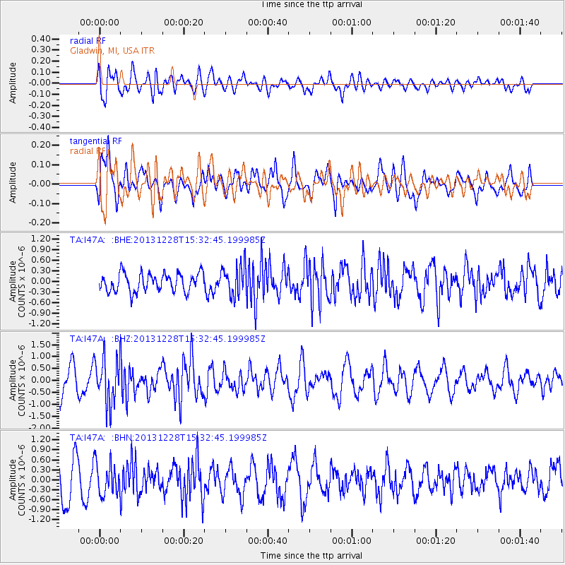
I47A Gladwin, MI, USA - Earthquake Result Viewer
*The percent match for this event was below the threshold and hence no stack was calculated.
| Earthquake location: |
Turkey |
| Earthquake latitude/longitude: |
36.0/31.3 |
| Earthquake time(UTC): |
2013/12/28 (362) 15:21:04 GMT |
| Earthquake Depth: |
41 km |
| Earthquake Magnitude: |
5.9 MWW, 5.9 MWB, 6.0 MWC |
| Earthquake Catalog/Contributor: |
NEIC PDE/NEIC COMCAT |
|
| Network: |
TA USArray Transportable Network (new EarthScope stations) |
| Station: |
I47A Gladwin, MI, USA |
| Lat/Lon: |
44.02 N/84.51 W |
| Elevation: |
269 m |
|
| Distance: |
81.3 deg |
| Az: |
318.934 deg |
| Baz: |
47.572 deg |
| Ray Param: |
$rayparam |
*The percent match for this event was below the threshold and hence was not used in the summary stack. |
|
| Radial Match: |
53.01916 % |
| Radial Bump: |
400 |
| Transverse Match: |
36.504337 % |
| Transverse Bump: |
395 |
| SOD ConfigId: |
626651 |
| Insert Time: |
2014-04-20 04:19:00.447 +0000 |
| GWidth: |
2.5 |
| Max Bumps: |
400 |
| Tol: |
0.001 |
|
Signal To Noise
| Channel | StoN | STA | LTA |
| TA:I47A: :BHZ:20131228T15:32:45.199985Z | 2.2750688 | 9.346845E-7 | 4.108379E-7 |
| TA:I47A: :BHN:20131228T15:32:45.199985Z | 0.8098953 | 4.426283E-7 | 5.4652537E-7 |
| TA:I47A: :BHE:20131228T15:32:45.199985Z | 1.7029936 | 4.4156104E-7 | 2.592852E-7 |
| Arrivals |
| Ps | |
| PpPs | |
| PsPs/PpSs | |


