You are here: Home > Network List > TA - USArray Transportable Network (new EarthScope stations) Stations List
> Station N49A Columbus Grove, OH, USA > Earthquake Result Viewer
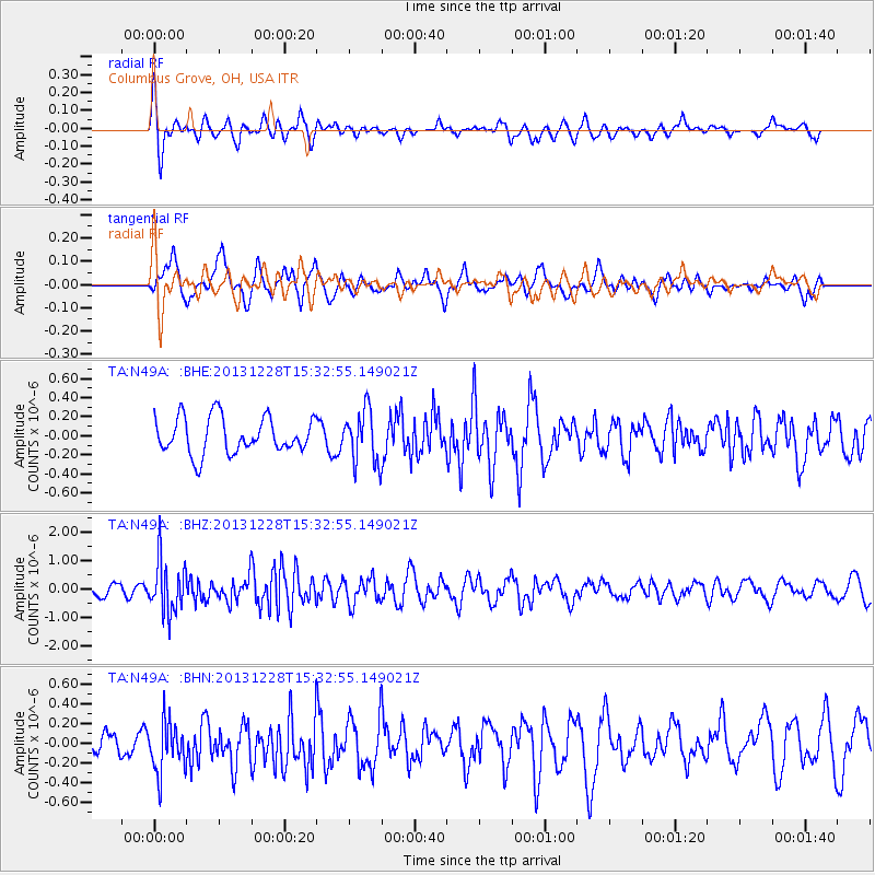
N49A Columbus Grove, OH, USA - Earthquake Result Viewer
*The percent match for this event was below the threshold and hence no stack was calculated.
| Earthquake location: |
Turkey |
| Earthquake latitude/longitude: |
36.0/31.3 |
| Earthquake time(UTC): |
2013/12/28 (362) 15:21:04 GMT |
| Earthquake Depth: |
41 km |
| Earthquake Magnitude: |
5.9 MWW, 5.9 MWB, 6.0 MWC |
| Earthquake Catalog/Contributor: |
NEIC PDE/NEIC COMCAT |
|
| Network: |
TA USArray Transportable Network (new EarthScope stations) |
| Station: |
N49A Columbus Grove, OH, USA |
| Lat/Lon: |
40.92 N/84.18 W |
| Elevation: |
225 m |
|
| Distance: |
83.2 deg |
| Az: |
316.466 deg |
| Baz: |
47.46 deg |
| Ray Param: |
$rayparam |
*The percent match for this event was below the threshold and hence was not used in the summary stack. |
|
| Radial Match: |
61.03671 % |
| Radial Bump: |
400 |
| Transverse Match: |
64.01193 % |
| Transverse Bump: |
400 |
| SOD ConfigId: |
626651 |
| Insert Time: |
2014-04-20 04:23:02.524 +0000 |
| GWidth: |
2.5 |
| Max Bumps: |
400 |
| Tol: |
0.001 |
|
Signal To Noise
| Channel | StoN | STA | LTA |
| TA:N49A: :BHZ:20131228T15:32:55.149021Z | 4.6453695 | 9.0749893E-7 | 1.9535558E-7 |
| TA:N49A: :BHN:20131228T15:32:55.149021Z | 1.4318385 | 2.6017244E-7 | 1.8170515E-7 |
| TA:N49A: :BHE:20131228T15:32:55.149021Z | 1.4739374 | 2.7787368E-7 | 1.8852475E-7 |
| Arrivals |
| Ps | |
| PpPs | |
| PsPs/PpSs | |


