You are here: Home > Network List > TA - USArray Transportable Network (new EarthScope stations) Stations List
> Station R56A Bull Pasture Mountain, McDowell, VA, USA > Earthquake Result Viewer
R56A Bull Pasture Mountain, McDowell, VA, USA - Earthquake Result Viewer
*The percent match for this event was below the threshold and hence no stack was calculated.
| Earthquake location: |
Turkey |
| Earthquake latitude/longitude: |
36.0/31.3 |
| Earthquake time(UTC): |
2013/12/28 (362) 15:21:04 GMT |
| Earthquake Depth: |
41 km |
| Earthquake Magnitude: |
5.9 MWW, 5.9 MWB, 6.0 MWC |
| Earthquake Catalog/Contributor: |
NEIC PDE/NEIC COMCAT |
|
| Network: |
TA USArray Transportable Network (new EarthScope stations) |
| Station: |
R56A Bull Pasture Mountain, McDowell, VA, USA |
| Lat/Lon: |
38.41 N/79.40 W |
| Elevation: |
902 m |
|
| Distance: |
82.1 deg |
| Az: |
312.11 deg |
| Baz: |
49.945 deg |
| Ray Param: |
$rayparam |
*The percent match for this event was below the threshold and hence was not used in the summary stack. |
|
| Radial Match: |
48.490784 % |
| Radial Bump: |
395 |
| Transverse Match: |
66.3868 % |
| Transverse Bump: |
400 |
| SOD ConfigId: |
626651 |
| Insert Time: |
2014-04-20 04:25:28.747 +0000 |
| GWidth: |
2.5 |
| Max Bumps: |
400 |
| Tol: |
0.001 |
|
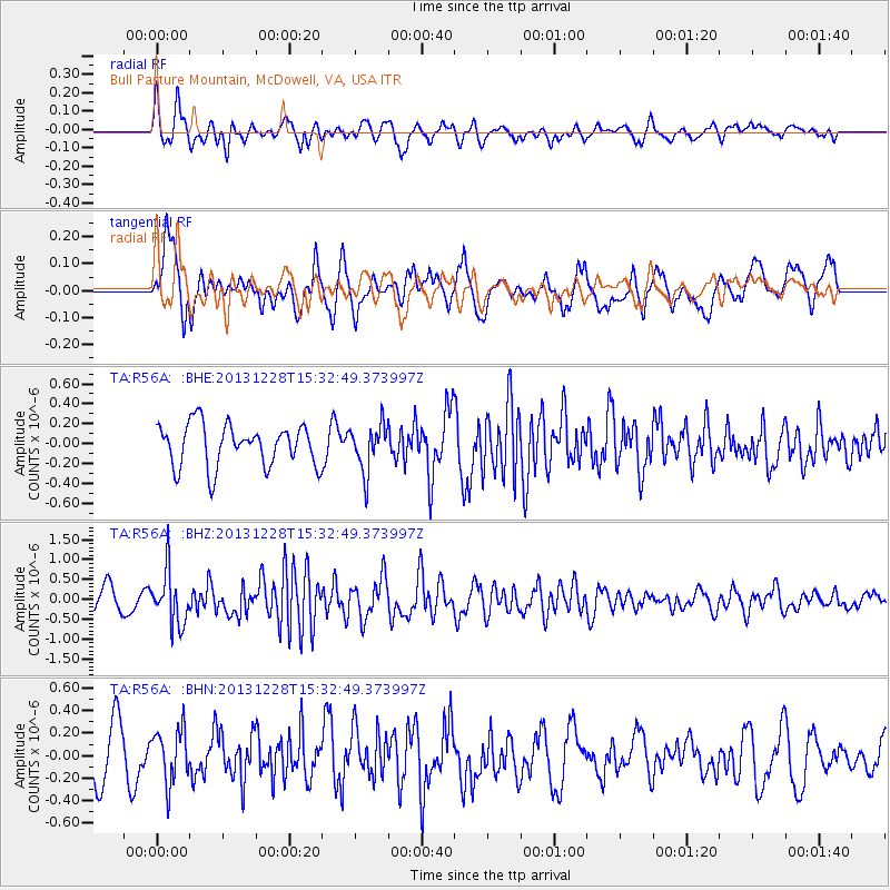
Signal To Noise
| Channel | StoN | STA | LTA |
| TA:R56A: :BHZ:20131228T15:32:49.373997Z | 2.5889304 | 6.6487155E-7 | 2.5681322E-7 |
| TA:R56A: :BHN:20131228T15:32:49.373997Z | 0.9497857 | 2.4314718E-7 | 2.5600215E-7 |
| TA:R56A: :BHE:20131228T15:32:49.373997Z | 1.103572 | 2.3262947E-7 | 2.1079681E-7 |
| Arrivals |
| Ps | |
| PpPs | |
| PsPs/PpSs | |


