You are here: Home > Network List > TA - USArray Transportable Network (new EarthScope stations) Stations List
> Station T52A Hallie, KY, USA > Earthquake Result Viewer
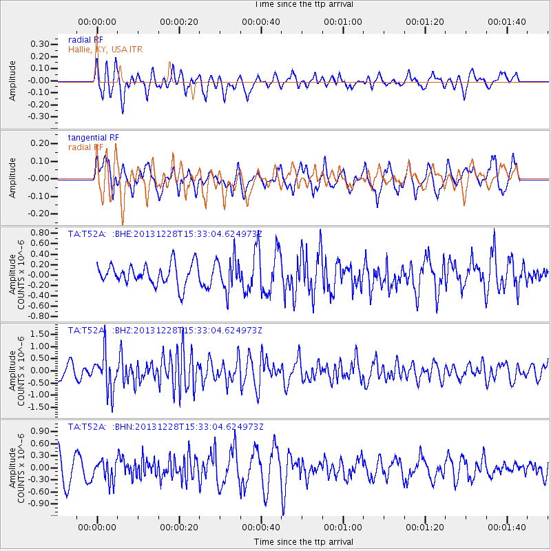
T52A Hallie, KY, USA - Earthquake Result Viewer
*The percent match for this event was below the threshold and hence no stack was calculated.
| Earthquake location: |
Turkey |
| Earthquake latitude/longitude: |
36.0/31.3 |
| Earthquake time(UTC): |
2013/12/28 (362) 15:21:04 GMT |
| Earthquake Depth: |
41 km |
| Earthquake Magnitude: |
5.9 MWW, 5.9 MWB, 6.0 MWC |
| Earthquake Catalog/Contributor: |
NEIC PDE/NEIC COMCAT |
|
| Network: |
TA USArray Transportable Network (new EarthScope stations) |
| Station: |
T52A Hallie, KY, USA |
| Lat/Lon: |
37.11 N/82.99 W |
| Elevation: |
436 m |
|
| Distance: |
85.1 deg |
| Az: |
313.004 deg |
| Baz: |
47.86 deg |
| Ray Param: |
$rayparam |
*The percent match for this event was below the threshold and hence was not used in the summary stack. |
|
| Radial Match: |
77.87507 % |
| Radial Bump: |
400 |
| Transverse Match: |
53.687008 % |
| Transverse Bump: |
400 |
| SOD ConfigId: |
626651 |
| Insert Time: |
2014-04-20 04:26:30.887 +0000 |
| GWidth: |
2.5 |
| Max Bumps: |
400 |
| Tol: |
0.001 |
|
Signal To Noise
| Channel | StoN | STA | LTA |
| TA:T52A: :BHZ:20131228T15:33:04.624973Z | 1.9374686 | 7.714325E-7 | 3.9816516E-7 |
| TA:T52A: :BHN:20131228T15:33:04.624973Z | 0.7842118 | 2.552421E-7 | 3.2547595E-7 |
| TA:T52A: :BHE:20131228T15:33:04.624973Z | 1.5924842 | 3.139837E-7 | 1.9716595E-7 |
| Arrivals |
| Ps | |
| PpPs | |
| PsPs/PpSs | |


