You are here: Home > Network List > TA - USArray Transportable Network (new EarthScope stations) Stations List
> Station T57A Hurt, VA, USA > Earthquake Result Viewer
T57A Hurt, VA, USA - Earthquake Result Viewer
*The percent match for this event was below the threshold and hence no stack was calculated.
| Earthquake location: |
Turkey |
| Earthquake latitude/longitude: |
36.0/31.3 |
| Earthquake time(UTC): |
2013/12/28 (362) 15:21:04 GMT |
| Earthquake Depth: |
41 km |
| Earthquake Magnitude: |
5.9 MWW, 5.9 MWB, 6.0 MWC |
| Earthquake Catalog/Contributor: |
NEIC PDE/NEIC COMCAT |
|
| Network: |
TA USArray Transportable Network (new EarthScope stations) |
| Station: |
T57A Hurt, VA, USA |
| Lat/Lon: |
37.00 N/79.25 W |
| Elevation: |
230 m |
|
| Distance: |
82.9 deg |
| Az: |
310.948 deg |
| Baz: |
49.885 deg |
| Ray Param: |
$rayparam |
*The percent match for this event was below the threshold and hence was not used in the summary stack. |
|
| Radial Match: |
52.04272 % |
| Radial Bump: |
400 |
| Transverse Match: |
46.933853 % |
| Transverse Bump: |
400 |
| SOD ConfigId: |
626651 |
| Insert Time: |
2014-04-20 04:26:43.590 +0000 |
| GWidth: |
2.5 |
| Max Bumps: |
400 |
| Tol: |
0.001 |
|
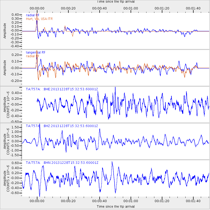
Signal To Noise
| Channel | StoN | STA | LTA |
| TA:T57A: :BHZ:20131228T15:32:53.60001Z | 3.601284 | 6.9273193E-7 | 1.9235692E-7 |
| TA:T57A: :BHN:20131228T15:32:53.60001Z | 1.7679492 | 3.2351778E-7 | 1.8299043E-7 |
| TA:T57A: :BHE:20131228T15:32:53.60001Z | 1.4990551 | 1.9893959E-7 | 1.3270999E-7 |
| Arrivals |
| Ps | |
| PpPs | |
| PsPs/PpSs | |


