You are here: Home > Network List > TA - USArray Transportable Network (new EarthScope stations) Stations List
> Station W61A Ground Anchor Farm, New Bern, NC, USA > Earthquake Result Viewer
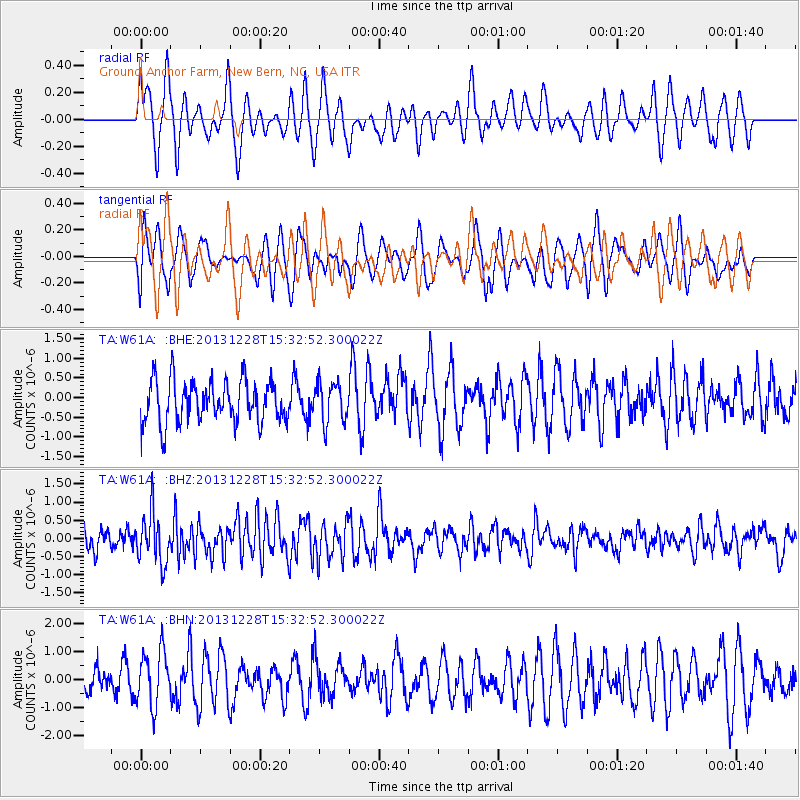
W61A Ground Anchor Farm, New Bern, NC, USA - Earthquake Result Viewer
*The percent match for this event was below the threshold and hence no stack was calculated.
| Earthquake location: |
Turkey |
| Earthquake latitude/longitude: |
36.0/31.3 |
| Earthquake time(UTC): |
2013/12/28 (362) 15:21:04 GMT |
| Earthquake Depth: |
41 km |
| Earthquake Magnitude: |
5.9 MWW, 5.9 MWB, 6.0 MWC |
| Earthquake Catalog/Contributor: |
NEIC PDE/NEIC COMCAT |
|
| Network: |
TA USArray Transportable Network (new EarthScope stations) |
| Station: |
W61A Ground Anchor Farm, New Bern, NC, USA |
| Lat/Lon: |
35.18 N/76.99 W |
| Elevation: |
6.0 m |
|
| Distance: |
82.7 deg |
| Az: |
308.359 deg |
| Baz: |
50.888 deg |
| Ray Param: |
$rayparam |
*The percent match for this event was below the threshold and hence was not used in the summary stack. |
|
| Radial Match: |
50.673084 % |
| Radial Bump: |
400 |
| Transverse Match: |
48.89725 % |
| Transverse Bump: |
400 |
| SOD ConfigId: |
626651 |
| Insert Time: |
2014-04-20 04:28:23.664 +0000 |
| GWidth: |
2.5 |
| Max Bumps: |
400 |
| Tol: |
0.001 |
|
Signal To Noise
| Channel | StoN | STA | LTA |
| TA:W61A: :BHZ:20131228T15:32:52.300022Z | 2.2010875 | 6.879493E-7 | 3.1254976E-7 |
| TA:W61A: :BHN:20131228T15:32:52.300022Z | 2.1722403 | 9.880006E-7 | 4.5483023E-7 |
| TA:W61A: :BHE:20131228T15:32:52.300022Z | 0.9441648 | 5.0453855E-7 | 5.343755E-7 |
| Arrivals |
| Ps | |
| PpPs | |
| PsPs/PpSs | |


