You are here: Home > Network List > TA - USArray Transportable Network (new EarthScope stations) Stations List
> Station X43A Marvell, AR, USA > Earthquake Result Viewer
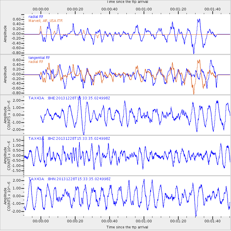
X43A Marvell, AR, USA - Earthquake Result Viewer
*The percent match for this event was below the threshold and hence no stack was calculated.
| Earthquake location: |
Turkey |
| Earthquake latitude/longitude: |
36.0/31.3 |
| Earthquake time(UTC): |
2013/12/28 (362) 15:21:04 GMT |
| Earthquake Depth: |
41 km |
| Earthquake Magnitude: |
5.9 MWW, 5.9 MWB, 6.0 MWC |
| Earthquake Catalog/Contributor: |
NEIC PDE/NEIC COMCAT |
|
| Network: |
TA USArray Transportable Network (new EarthScope stations) |
| Station: |
X43A Marvell, AR, USA |
| Lat/Lon: |
34.52 N/90.88 W |
| Elevation: |
53 m |
|
| Distance: |
91.5 deg |
| Az: |
315.651 deg |
| Baz: |
43.332 deg |
| Ray Param: |
$rayparam |
*The percent match for this event was below the threshold and hence was not used in the summary stack. |
|
| Radial Match: |
60.126373 % |
| Radial Bump: |
400 |
| Transverse Match: |
51.451046 % |
| Transverse Bump: |
400 |
| SOD ConfigId: |
626651 |
| Insert Time: |
2014-04-20 04:28:29.846 +0000 |
| GWidth: |
2.5 |
| Max Bumps: |
400 |
| Tol: |
0.001 |
|
Signal To Noise
| Channel | StoN | STA | LTA |
| TA:X43A: :BHZ:20131228T15:33:35.024998Z | 2.3196976 | 7.161299E-7 | 3.087169E-7 |
| TA:X43A: :BHN:20131228T15:33:35.024998Z | 0.95930606 | 1.0744445E-6 | 1.1200226E-6 |
| TA:X43A: :BHE:20131228T15:33:35.024998Z | 0.5197989 | 4.7489598E-7 | 9.136148E-7 |
| Arrivals |
| Ps | |
| PpPs | |
| PsPs/PpSs | |


