You are here: Home > Network List > UW - Pacific Northwest Regional Seismic Network Stations List
> Station PASS Maple Falls, WA, USA > Earthquake Result Viewer
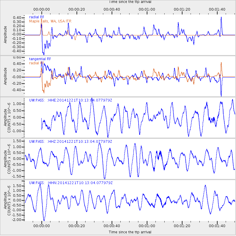
PASS Maple Falls, WA, USA - Earthquake Result Viewer
*The percent match for this event was below the threshold and hence no stack was calculated.
| Earthquake location: |
Samar, Philippines |
| Earthquake latitude/longitude: |
11.5/126.0 |
| Earthquake time(UTC): |
2014/12/21 (355) 10:00:15 GMT |
| Earthquake Depth: |
37 km |
| Earthquake Magnitude: |
5.2 MW, 5.4 mb, 4.9 MS |
| Earthquake Catalog/Contributor: |
ISC/ISC |
|
| Network: |
UW Pacific Northwest Regional Seismic Network |
| Station: |
PASS Maple Falls, WA, USA |
| Lat/Lon: |
49.00 N/122.09 W |
| Elevation: |
174 m |
|
| Distance: |
95.3 deg |
| Az: |
37.848 deg |
| Baz: |
294.043 deg |
| Ray Param: |
$rayparam |
*The percent match for this event was below the threshold and hence was not used in the summary stack. |
|
| Radial Match: |
61.23016 % |
| Radial Bump: |
400 |
| Transverse Match: |
57.16733 % |
| Transverse Bump: |
400 |
| SOD ConfigId: |
3390531 |
| Insert Time: |
2019-04-15 17:26:17.258 +0000 |
| GWidth: |
2.5 |
| Max Bumps: |
400 |
| Tol: |
0.001 |
|
Signal To Noise
| Channel | StoN | STA | LTA |
| UW:PASS: :HHZ:20141221T10:13:04.077979Z | 0.84262925 | 4.865174E-7 | 5.7738015E-7 |
| UW:PASS: :HHN:20141221T10:13:04.077979Z | 3.8143268 | 1.3020598E-6 | 3.4136033E-7 |
| UW:PASS: :HHE:20141221T10:13:04.077979Z | 1.2559854 | 7.386613E-7 | 5.881129E-7 |
| Arrivals |
| Ps | |
| PpPs | |
| PsPs/PpSs | |


