You are here: Home > Network List > US - United States National Seismic Network Stations List
> Station EGMT Eagleton, Montana, USA > Earthquake Result Viewer
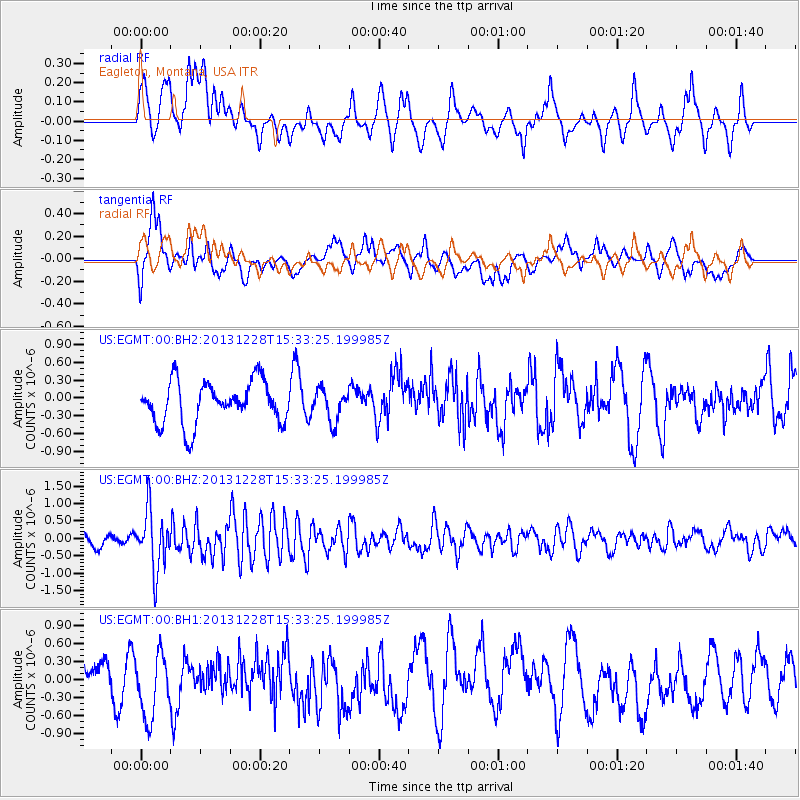
EGMT Eagleton, Montana, USA - Earthquake Result Viewer
*The percent match for this event was below the threshold and hence no stack was calculated.
| Earthquake location: |
Turkey |
| Earthquake latitude/longitude: |
36.0/31.3 |
| Earthquake time(UTC): |
2013/12/28 (362) 15:21:04 GMT |
| Earthquake Depth: |
41 km |
| Earthquake Magnitude: |
5.9 MWW, 5.9 MWB, 6.0 MWC |
| Earthquake Catalog/Contributor: |
NEIC PDE/NEIC COMCAT |
|
| Network: |
US United States National Seismic Network |
| Station: |
EGMT Eagleton, Montana, USA |
| Lat/Lon: |
48.02 N/109.75 W |
| Elevation: |
1055 m |
|
| Distance: |
89.4 deg |
| Az: |
335.046 deg |
| Baz: |
30.627 deg |
| Ray Param: |
$rayparam |
*The percent match for this event was below the threshold and hence was not used in the summary stack. |
|
| Radial Match: |
51.926575 % |
| Radial Bump: |
400 |
| Transverse Match: |
56.147984 % |
| Transverse Bump: |
400 |
| SOD ConfigId: |
626651 |
| Insert Time: |
2014-04-20 04:30:52.030 +0000 |
| GWidth: |
2.5 |
| Max Bumps: |
400 |
| Tol: |
0.001 |
|
Signal To Noise
| Channel | StoN | STA | LTA |
| US:EGMT:00:BHZ:20131228T15:33:25.199985Z | 4.069679 | 8.490533E-7 | 2.0862907E-7 |
| US:EGMT:00:BH1:20131228T15:33:25.199985Z | 1.6456115 | 5.2530936E-7 | 3.1921834E-7 |
| US:EGMT:00:BH2:20131228T15:33:25.199985Z | 0.7465482 | 2.654596E-7 | 3.5558264E-7 |
| Arrivals |
| Ps | |
| PpPs | |
| PsPs/PpSs | |


