You are here: Home > Network List > IW - Intermountain West Stations List
> Station MOOW Moose Ponds, Wyoming, USA > Earthquake Result Viewer
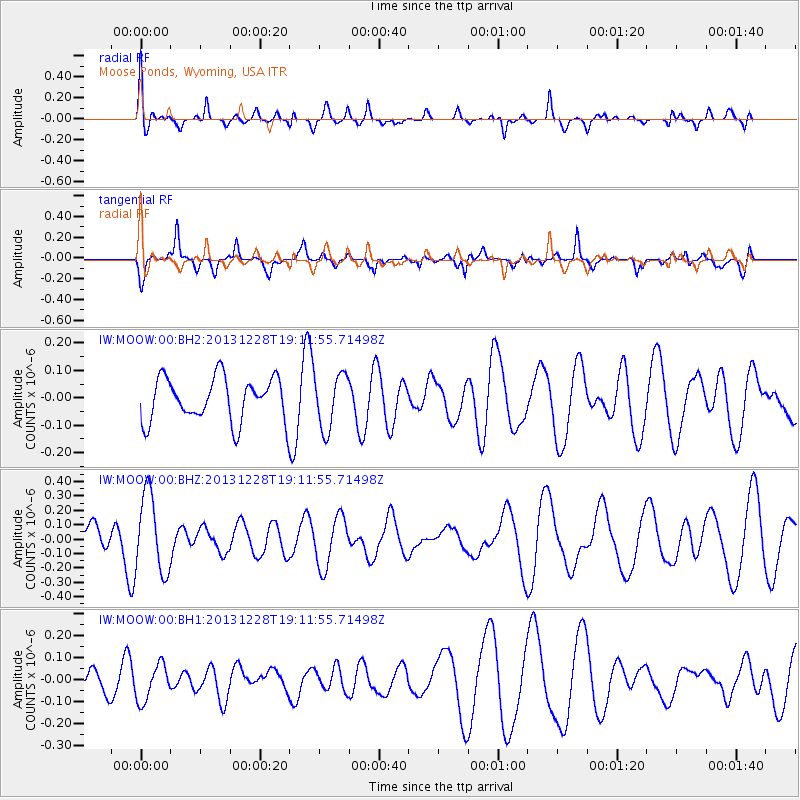
MOOW Moose Ponds, Wyoming, USA - Earthquake Result Viewer
*The percent match for this event was below the threshold and hence no stack was calculated.
| Earthquake location: |
North Of Ascension Island |
| Earthquake latitude/longitude: |
-1.4/-15.2 |
| Earthquake time(UTC): |
2013/12/28 (362) 18:59:04 GMT |
| Earthquake Depth: |
10 km |
| Earthquake Magnitude: |
5.8 MWW, 5.8 MWB, 6.0 MWC |
| Earthquake Catalog/Contributor: |
NEIC PDE/NEIC COMCAT |
|
| Network: |
IW Intermountain West |
| Station: |
MOOW Moose Ponds, Wyoming, USA |
| Lat/Lon: |
43.75 N/110.74 W |
| Elevation: |
2128 m |
|
| Distance: |
95.0 deg |
| Az: |
313.615 deg |
| Baz: |
87.139 deg |
| Ray Param: |
$rayparam |
*The percent match for this event was below the threshold and hence was not used in the summary stack. |
|
| Radial Match: |
58.7785 % |
| Radial Bump: |
400 |
| Transverse Match: |
56.69123 % |
| Transverse Bump: |
400 |
| SOD ConfigId: |
626651 |
| Insert Time: |
2014-04-20 04:39:02.946 +0000 |
| GWidth: |
2.5 |
| Max Bumps: |
400 |
| Tol: |
0.001 |
|
Signal To Noise
| Channel | StoN | STA | LTA |
| IW:MOOW:00:BHZ:20131228T19:11:55.71498Z | 2.6923518 | 2.711279E-7 | 1.0070299E-7 |
| IW:MOOW:00:BH1:20131228T19:11:55.71498Z | 0.94571954 | 8.3511836E-8 | 8.830508E-8 |
| IW:MOOW:00:BH2:20131228T19:11:55.71498Z | 1.2514331 | 9.996185E-8 | 7.987789E-8 |
| Arrivals |
| Ps | |
| PpPs | |
| PsPs/PpSs | |


