You are here: Home > Network List > TA - USArray Transportable Network (new EarthScope stations) Stations List
> Station H48A Harrisville, MI, USA > Earthquake Result Viewer
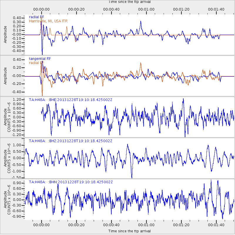
H48A Harrisville, MI, USA - Earthquake Result Viewer
*The percent match for this event was below the threshold and hence no stack was calculated.
| Earthquake location: |
North Of Ascension Island |
| Earthquake latitude/longitude: |
-1.4/-15.2 |
| Earthquake time(UTC): |
2013/12/28 (362) 18:59:04 GMT |
| Earthquake Depth: |
10 km |
| Earthquake Magnitude: |
5.8 MWW, 5.8 MWB, 6.0 MWC |
| Earthquake Catalog/Contributor: |
NEIC PDE/NEIC COMCAT |
|
| Network: |
TA USArray Transportable Network (new EarthScope stations) |
| Station: |
H48A Harrisville, MI, USA |
| Lat/Lon: |
44.70 N/83.32 W |
| Elevation: |
244 m |
|
| Distance: |
75.6 deg |
| Az: |
316.89 deg |
| Baz: |
106.66 deg |
| Ray Param: |
$rayparam |
*The percent match for this event was below the threshold and hence was not used in the summary stack. |
|
| Radial Match: |
53.801186 % |
| Radial Bump: |
400 |
| Transverse Match: |
58.019775 % |
| Transverse Bump: |
400 |
| SOD ConfigId: |
626651 |
| Insert Time: |
2014-04-20 04:45:01.554 +0000 |
| GWidth: |
2.5 |
| Max Bumps: |
400 |
| Tol: |
0.001 |
|
Signal To Noise
| Channel | StoN | STA | LTA |
| TA:H48A: :BHZ:20131228T19:10:18.425002Z | 0.72132343 | 3.1004393E-7 | 4.2982649E-7 |
| TA:H48A: :BHN:20131228T19:10:18.425002Z | 1.0102364 | 3.11222E-7 | 3.080685E-7 |
| TA:H48A: :BHE:20131228T19:10:18.425002Z | 0.99524796 | 4.1182355E-7 | 4.1378988E-7 |
| Arrivals |
| Ps | |
| PpPs | |
| PsPs/PpSs | |


