You are here: Home > Network List > TA - USArray Transportable Network (new EarthScope stations) Stations List
> Station U58A Oxford, NC, USA > Earthquake Result Viewer
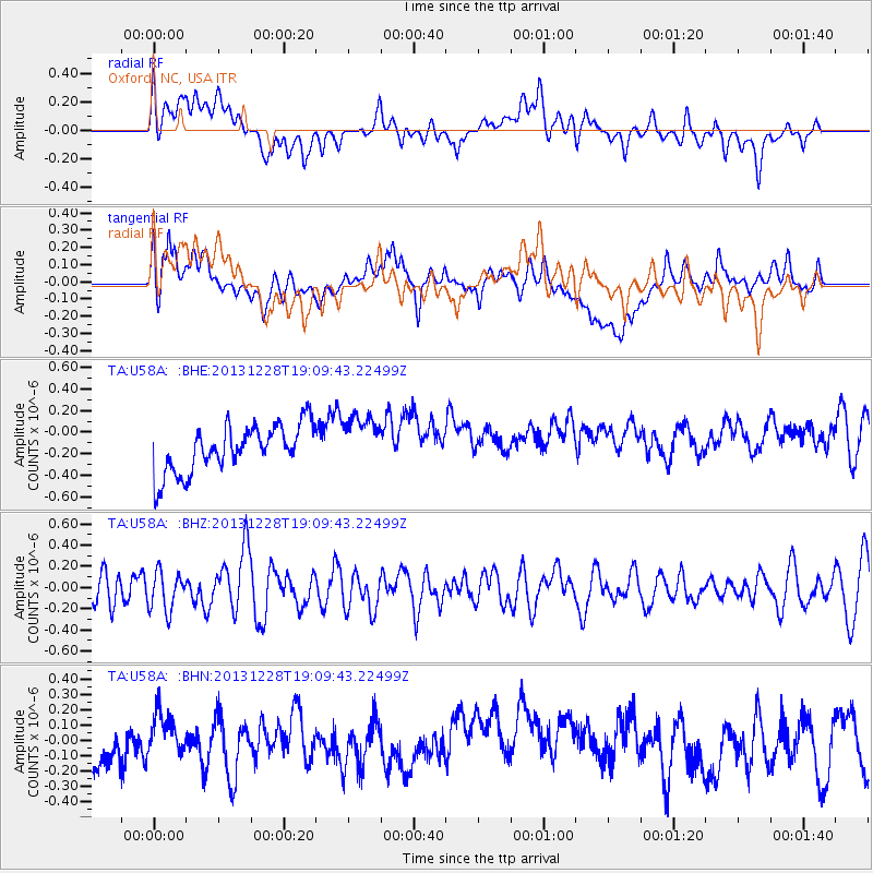
U58A Oxford, NC, USA - Earthquake Result Viewer
*The percent match for this event was below the threshold and hence no stack was calculated.
| Earthquake location: |
North Of Ascension Island |
| Earthquake latitude/longitude: |
-1.4/-15.2 |
| Earthquake time(UTC): |
2013/12/28 (362) 18:59:04 GMT |
| Earthquake Depth: |
10 km |
| Earthquake Magnitude: |
5.8 MWW, 5.8 MWB, 6.0 MWC |
| Earthquake Catalog/Contributor: |
NEIC PDE/NEIC COMCAT |
|
| Network: |
TA USArray Transportable Network (new EarthScope stations) |
| Station: |
U58A Oxford, NC, USA |
| Lat/Lon: |
36.39 N/78.55 W |
| Elevation: |
169 m |
|
| Distance: |
69.7 deg |
| Az: |
309.715 deg |
| Baz: |
107.615 deg |
| Ray Param: |
$rayparam |
*The percent match for this event was below the threshold and hence was not used in the summary stack. |
|
| Radial Match: |
38.48685 % |
| Radial Bump: |
400 |
| Transverse Match: |
41.093796 % |
| Transverse Bump: |
400 |
| SOD ConfigId: |
626651 |
| Insert Time: |
2014-04-20 04:48:35.975 +0000 |
| GWidth: |
2.5 |
| Max Bumps: |
400 |
| Tol: |
0.001 |
|
Signal To Noise
| Channel | StoN | STA | LTA |
| TA:U58A: :BHZ:20131228T19:09:43.22499Z | 1.3469341 | 1.8254283E-7 | 1.355247E-7 |
| TA:U58A: :BHN:20131228T19:09:43.22499Z | 0.41478005 | 1.1288938E-7 | 2.7216686E-7 |
| TA:U58A: :BHE:20131228T19:09:43.22499Z | 1.1432713 | 2.4935366E-7 | 2.181054E-7 |
| Arrivals |
| Ps | |
| PpPs | |
| PsPs/PpSs | |


