You are here: Home > Network List > TA - USArray Transportable Network (new EarthScope stations) Stations List
> Station Y57A Sumter, SC, USA > Earthquake Result Viewer
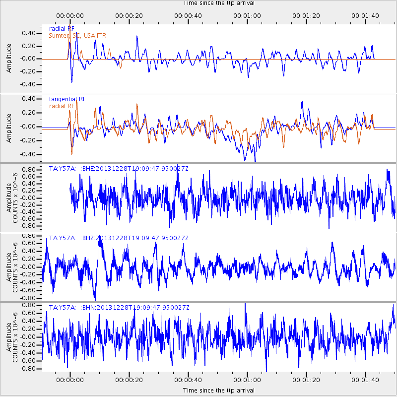
Y57A Sumter, SC, USA - Earthquake Result Viewer
*The percent match for this event was below the threshold and hence no stack was calculated.
| Earthquake location: |
North Of Ascension Island |
| Earthquake latitude/longitude: |
-1.4/-15.2 |
| Earthquake time(UTC): |
2013/12/28 (362) 18:59:04 GMT |
| Earthquake Depth: |
10 km |
| Earthquake Magnitude: |
5.8 MWW, 5.8 MWB, 6.0 MWC |
| Earthquake Catalog/Contributor: |
NEIC PDE/NEIC COMCAT |
|
| Network: |
TA USArray Transportable Network (new EarthScope stations) |
| Station: |
Y57A Sumter, SC, USA |
| Lat/Lon: |
34.02 N/80.39 W |
| Elevation: |
56 m |
|
| Distance: |
70.4 deg |
| Az: |
306.838 deg |
| Baz: |
105.576 deg |
| Ray Param: |
$rayparam |
*The percent match for this event was below the threshold and hence was not used in the summary stack. |
|
| Radial Match: |
62.548996 % |
| Radial Bump: |
400 |
| Transverse Match: |
36.27394 % |
| Transverse Bump: |
400 |
| SOD ConfigId: |
626651 |
| Insert Time: |
2014-04-20 04:49:25.369 +0000 |
| GWidth: |
2.5 |
| Max Bumps: |
400 |
| Tol: |
0.001 |
|
Signal To Noise
| Channel | StoN | STA | LTA |
| TA:Y57A: :BHZ:20131228T19:09:47.950027Z | 0.84560364 | 1.881279E-7 | 2.2247762E-7 |
| TA:Y57A: :BHN:20131228T19:09:47.950027Z | 0.93172956 | 3.462248E-7 | 3.7159364E-7 |
| TA:Y57A: :BHE:20131228T19:09:47.950027Z | 0.9936503 | 2.776323E-7 | 2.7940644E-7 |
| Arrivals |
| Ps | |
| PpPs | |
| PsPs/PpSs | |


