You are here: Home > Network List > US - United States National Seismic Network Stations List
> Station ACSO Alum Creek State Park, Ohio, USA > Earthquake Result Viewer
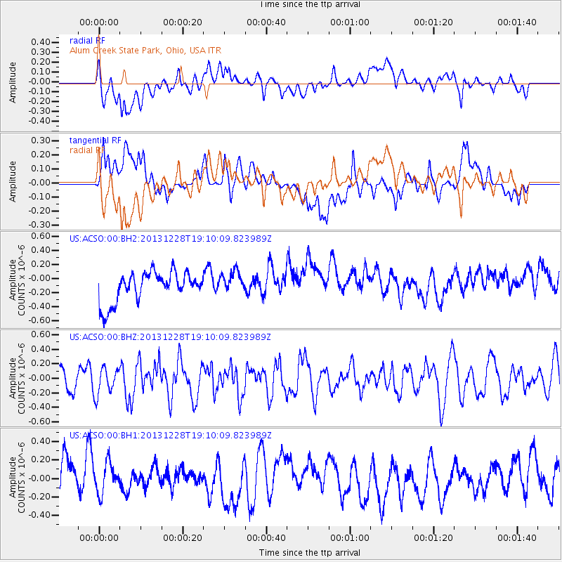
ACSO Alum Creek State Park, Ohio, USA - Earthquake Result Viewer
*The percent match for this event was below the threshold and hence no stack was calculated.
| Earthquake location: |
North Of Ascension Island |
| Earthquake latitude/longitude: |
-1.4/-15.2 |
| Earthquake time(UTC): |
2013/12/28 (362) 18:59:04 GMT |
| Earthquake Depth: |
10 km |
| Earthquake Magnitude: |
5.8 MWW, 5.8 MWB, 6.0 MWC |
| Earthquake Catalog/Contributor: |
NEIC PDE/NEIC COMCAT |
|
| Network: |
US United States National Seismic Network |
| Station: |
ACSO Alum Creek State Park, Ohio, USA |
| Lat/Lon: |
40.23 N/82.98 W |
| Elevation: |
288 m |
|
| Distance: |
74.1 deg |
| Az: |
312.52 deg |
| Baz: |
105.749 deg |
| Ray Param: |
$rayparam |
*The percent match for this event was below the threshold and hence was not used in the summary stack. |
|
| Radial Match: |
46.875637 % |
| Radial Bump: |
400 |
| Transverse Match: |
43.829937 % |
| Transverse Bump: |
400 |
| SOD ConfigId: |
626651 |
| Insert Time: |
2014-04-20 04:49:51.493 +0000 |
| GWidth: |
2.5 |
| Max Bumps: |
400 |
| Tol: |
0.001 |
|
Signal To Noise
| Channel | StoN | STA | LTA |
| US:ACSO:00:BHZ:20131228T19:10:09.823989Z | 1.3711233 | 1.7731335E-7 | 1.2931977E-7 |
| US:ACSO:00:BH1:20131228T19:10:09.823989Z | 0.73755187 | 1.9936286E-7 | 2.703035E-7 |
| US:ACSO:00:BH2:20131228T19:10:09.823989Z | 0.75693417 | 1.628659E-7 | 2.1516522E-7 |
| Arrivals |
| Ps | |
| PpPs | |
| PsPs/PpSs | |


