You are here: Home > Network List > BK - Berkeley Digital Seismograph Network Stations List
> Station HUMO Hull Mountain, OR > Earthquake Result Viewer
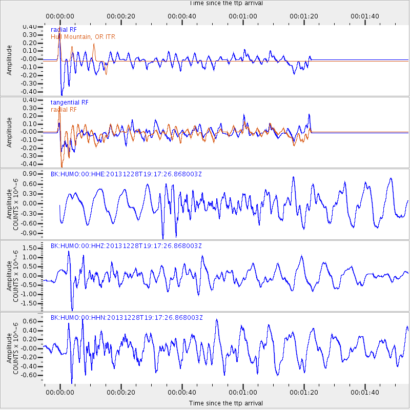
HUMO Hull Mountain, OR - Earthquake Result Viewer
*The percent match for this event was below the threshold and hence no stack was calculated.
| Earthquake location: |
Tonga Islands |
| Earthquake latitude/longitude: |
-18.2/-174.3 |
| Earthquake time(UTC): |
2013/12/28 (362) 19:06:16 GMT |
| Earthquake Depth: |
96 km |
| Earthquake Magnitude: |
5.9 MWW, 5.9 MWB, 5.9 MWC |
| Earthquake Catalog/Contributor: |
NEIC PDE/NEIC COMCAT |
|
| Network: |
BK Berkeley Digital Seismograph Network |
| Station: |
HUMO Hull Mountain, OR |
| Lat/Lon: |
42.61 N/122.96 W |
| Elevation: |
555 m |
|
| Distance: |
76.8 deg |
| Az: |
36.327 deg |
| Baz: |
229.707 deg |
| Ray Param: |
$rayparam |
*The percent match for this event was below the threshold and hence was not used in the summary stack. |
|
| Radial Match: |
68.05309 % |
| Radial Bump: |
400 |
| Transverse Match: |
68.90304 % |
| Transverse Bump: |
400 |
| SOD ConfigId: |
626651 |
| Insert Time: |
2014-04-20 04:55:56.321 +0000 |
| GWidth: |
2.5 |
| Max Bumps: |
400 |
| Tol: |
0.001 |
|
Signal To Noise
| Channel | StoN | STA | LTA |
| BK:HUMO:00:HHZ:20131228T19:17:26.868003Z | 2.7610736 | 7.683354E-7 | 2.7827414E-7 |
| BK:HUMO:00:HHN:20131228T19:17:26.868003Z | 1.5066 | 2.6255273E-7 | 1.7426838E-7 |
| BK:HUMO:00:HHE:20131228T19:17:26.868003Z | 1.2753091 | 4.137728E-7 | 3.2444902E-7 |
| Arrivals |
| Ps | |
| PpPs | |
| PsPs/PpSs | |


