You are here: Home > Network List > IU - Global Seismograph Network (GSN - IRIS/USGS) Stations List
> Station CTAO Charters Towers, Australia > Earthquake Result Viewer
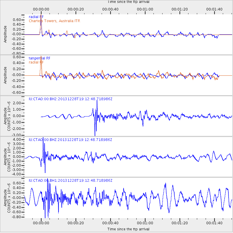
CTAO Charters Towers, Australia - Earthquake Result Viewer
*The percent match for this event was below the threshold and hence no stack was calculated.
| Earthquake location: |
Tonga Islands |
| Earthquake latitude/longitude: |
-18.2/-174.3 |
| Earthquake time(UTC): |
2013/12/28 (362) 19:06:16 GMT |
| Earthquake Depth: |
96 km |
| Earthquake Magnitude: |
5.9 MWW, 5.9 MWB, 5.9 MWC |
| Earthquake Catalog/Contributor: |
NEIC PDE/NEIC COMCAT |
|
| Network: |
IU Global Seismograph Network (GSN - IRIS/USGS) |
| Station: |
CTAO Charters Towers, Australia |
| Lat/Lon: |
20.09 S/146.25 E |
| Elevation: |
357 m |
|
| Distance: |
37.2 deg |
| Az: |
260.568 deg |
| Baz: |
93.895 deg |
| Ray Param: |
$rayparam |
*The percent match for this event was below the threshold and hence was not used in the summary stack. |
|
| Radial Match: |
74.42915 % |
| Radial Bump: |
308 |
| Transverse Match: |
54.704834 % |
| Transverse Bump: |
350 |
| SOD ConfigId: |
626651 |
| Insert Time: |
2014-04-20 05:00:24.923 +0000 |
| GWidth: |
2.5 |
| Max Bumps: |
400 |
| Tol: |
0.001 |
|
Signal To Noise
| Channel | StoN | STA | LTA |
| IU:CTAO:00:BHZ:20131228T19:12:48.718986Z | 8.605866 | 1.4702175E-6 | 1.7083899E-7 |
| IU:CTAO:00:BH1:20131228T19:12:48.718986Z | 2.3471344 | 3.445271E-7 | 1.4678628E-7 |
| IU:CTAO:00:BH2:20131228T19:12:48.718986Z | 6.1124845 | 9.643858E-7 | 1.5777312E-7 |
| Arrivals |
| Ps | |
| PpPs | |
| PsPs/PpSs | |


