You are here: Home > Network List > US - United States National Seismic Network Stations List
> Station EGMT Eagleton, Montana, USA > Earthquake Result Viewer
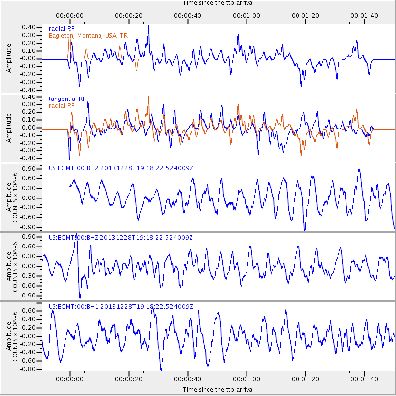
EGMT Eagleton, Montana, USA - Earthquake Result Viewer
*The percent match for this event was below the threshold and hence no stack was calculated.
| Earthquake location: |
Tonga Islands |
| Earthquake latitude/longitude: |
-18.2/-174.3 |
| Earthquake time(UTC): |
2013/12/28 (362) 19:06:16 GMT |
| Earthquake Depth: |
96 km |
| Earthquake Magnitude: |
5.9 MWW, 5.9 MWB, 5.9 MWC |
| Earthquake Catalog/Contributor: |
NEIC PDE/NEIC COMCAT |
|
| Network: |
US United States National Seismic Network |
| Station: |
EGMT Eagleton, Montana, USA |
| Lat/Lon: |
48.02 N/109.75 W |
| Elevation: |
1055 m |
|
| Distance: |
87.5 deg |
| Az: |
37.36 deg |
| Baz: |
239.236 deg |
| Ray Param: |
$rayparam |
*The percent match for this event was below the threshold and hence was not used in the summary stack. |
|
| Radial Match: |
52.22308 % |
| Radial Bump: |
400 |
| Transverse Match: |
49.587 % |
| Transverse Bump: |
400 |
| SOD ConfigId: |
626651 |
| Insert Time: |
2014-04-20 05:07:55.342 +0000 |
| GWidth: |
2.5 |
| Max Bumps: |
400 |
| Tol: |
0.001 |
|
Signal To Noise
| Channel | StoN | STA | LTA |
| US:EGMT:00:BHZ:20131228T19:18:22.524009Z | 2.8877745 | 5.5923084E-7 | 1.9365461E-7 |
| US:EGMT:00:BH1:20131228T19:18:22.524009Z | 0.5256269 | 1.6001616E-7 | 3.0442916E-7 |
| US:EGMT:00:BH2:20131228T19:18:22.524009Z | 1.0705613 | 3.0842128E-7 | 2.8809305E-7 |
| Arrivals |
| Ps | |
| PpPs | |
| PsPs/PpSs | |


