You are here: Home > Network List > US - United States National Seismic Network Stations List
> Station MNTX Cornudas Mountains, Texas, USA > Earthquake Result Viewer
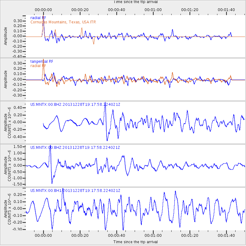
MNTX Cornudas Mountains, Texas, USA - Earthquake Result Viewer
*The percent match for this event was below the threshold and hence no stack was calculated.
| Earthquake location: |
Tonga Islands |
| Earthquake latitude/longitude: |
-18.2/-174.3 |
| Earthquake time(UTC): |
2013/12/28 (362) 19:06:16 GMT |
| Earthquake Depth: |
96 km |
| Earthquake Magnitude: |
5.9 MWW, 5.9 MWB, 5.9 MWC |
| Earthquake Catalog/Contributor: |
NEIC PDE/NEIC COMCAT |
|
| Network: |
US United States National Seismic Network |
| Station: |
MNTX Cornudas Mountains, Texas, USA |
| Lat/Lon: |
31.70 N/105.38 W |
| Elevation: |
404 m |
|
| Distance: |
82.6 deg |
| Az: |
53.335 deg |
| Baz: |
243.449 deg |
| Ray Param: |
$rayparam |
*The percent match for this event was below the threshold and hence was not used in the summary stack. |
|
| Radial Match: |
72.30597 % |
| Radial Bump: |
400 |
| Transverse Match: |
61.23849 % |
| Transverse Bump: |
400 |
| SOD ConfigId: |
626651 |
| Insert Time: |
2014-04-20 05:08:19.929 +0000 |
| GWidth: |
2.5 |
| Max Bumps: |
400 |
| Tol: |
0.001 |
|
Signal To Noise
| Channel | StoN | STA | LTA |
| US:MNTX:00:BHZ:20131228T19:17:58.224021Z | 8.077025 | 6.784931E-7 | 8.400285E-8 |
| US:MNTX:00:BH1:20131228T19:17:58.224021Z | 1.6145737 | 1.17067145E-7 | 7.250654E-8 |
| US:MNTX:00:BH2:20131228T19:17:58.224021Z | 2.2012334 | 2.2141295E-7 | 1.0058586E-7 |
| Arrivals |
| Ps | |
| PpPs | |
| PsPs/PpSs | |


