You are here: Home > Network List > US - United States National Seismic Network Stations List
> Station NATX Nacogdoches, Texas, USA > Earthquake Result Viewer
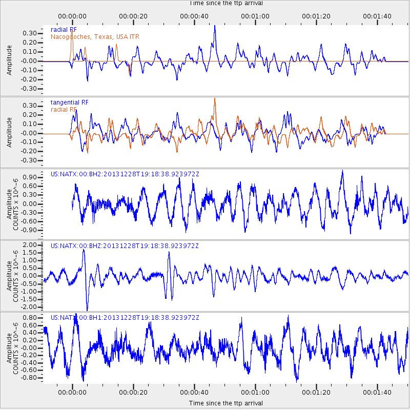
NATX Nacogdoches, Texas, USA - Earthquake Result Viewer
*The percent match for this event was below the threshold and hence no stack was calculated.
| Earthquake location: |
Tonga Islands |
| Earthquake latitude/longitude: |
-18.2/-174.3 |
| Earthquake time(UTC): |
2013/12/28 (362) 19:06:16 GMT |
| Earthquake Depth: |
96 km |
| Earthquake Magnitude: |
5.9 MWW, 5.9 MWB, 5.9 MWC |
| Earthquake Catalog/Contributor: |
NEIC PDE/NEIC COMCAT |
|
| Network: |
US United States National Seismic Network |
| Station: |
NATX Nacogdoches, Texas, USA |
| Lat/Lon: |
31.76 N/94.66 W |
| Elevation: |
156 m |
|
| Distance: |
91.0 deg |
| Az: |
56.943 deg |
| Baz: |
249.274 deg |
| Ray Param: |
$rayparam |
*The percent match for this event was below the threshold and hence was not used in the summary stack. |
|
| Radial Match: |
58.017185 % |
| Radial Bump: |
396 |
| Transverse Match: |
55.43544 % |
| Transverse Bump: |
396 |
| SOD ConfigId: |
626651 |
| Insert Time: |
2014-04-20 05:08:25.295 +0000 |
| GWidth: |
2.5 |
| Max Bumps: |
400 |
| Tol: |
0.001 |
|
Signal To Noise
| Channel | StoN | STA | LTA |
| US:NATX:00:BHZ:20131228T19:18:38.923972Z | 4.5749974 | 8.205806E-7 | 1.7936199E-7 |
| US:NATX:00:BH1:20131228T19:18:38.923972Z | 1.4499394 | 5.246389E-7 | 3.6183505E-7 |
| US:NATX:00:BH2:20131228T19:18:38.923972Z | 1.6584989 | 4.246273E-7 | 2.5603111E-7 |
| Arrivals |
| Ps | |
| PpPs | |
| PsPs/PpSs | |


