You are here: Home > Network List > IU - Global Seismograph Network (GSN - IRIS/USGS) Stations List
> Station PMG Port Moresby, New Guinea > Earthquake Result Viewer
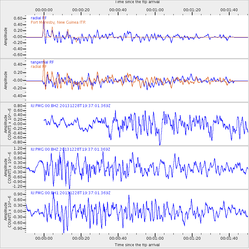
PMG Port Moresby, New Guinea - Earthquake Result Viewer
*The percent match for this event was below the threshold and hence no stack was calculated.
| Earthquake location: |
Mariana Islands Region |
| Earthquake latitude/longitude: |
20.8/146.7 |
| Earthquake time(UTC): |
2013/12/28 (362) 19:31:23 GMT |
| Earthquake Depth: |
12 km |
| Earthquake Magnitude: |
5.6 MWC, 5.6 MWC |
| Earthquake Catalog/Contributor: |
NEIC PDE/NEIC COMCAT |
|
| Network: |
IU Global Seismograph Network (GSN - IRIS/USGS) |
| Station: |
PMG Port Moresby, New Guinea |
| Lat/Lon: |
9.40 S/147.16 E |
| Elevation: |
90 m |
|
| Distance: |
30.0 deg |
| Az: |
179.026 deg |
| Baz: |
359.076 deg |
| Ray Param: |
$rayparam |
*The percent match for this event was below the threshold and hence was not used in the summary stack. |
|
| Radial Match: |
70.49074 % |
| Radial Bump: |
400 |
| Transverse Match: |
54.21059 % |
| Transverse Bump: |
400 |
| SOD ConfigId: |
626651 |
| Insert Time: |
2014-04-20 05:19:39.738 +0000 |
| GWidth: |
2.5 |
| Max Bumps: |
400 |
| Tol: |
0.001 |
|
Signal To Noise
| Channel | StoN | STA | LTA |
| IU:PMG:00:BHZ:20131228T19:37:01.369Z | 3.0168014 | 4.2087737E-7 | 1.3951113E-7 |
| IU:PMG:00:BH1:20131228T19:37:01.369Z | 1.3791525 | 2.6601958E-7 | 1.9288626E-7 |
| IU:PMG:00:BH2:20131228T19:37:01.369Z | 0.8371666 | 1.3426046E-7 | 1.6037482E-7 |
| Arrivals |
| Ps | |
| PpPs | |
| PsPs/PpSs | |


