You are here: Home > Network List > AK - Alaska Regional Network Stations List
> Station MDM Murphy Dome > Earthquake Result Viewer
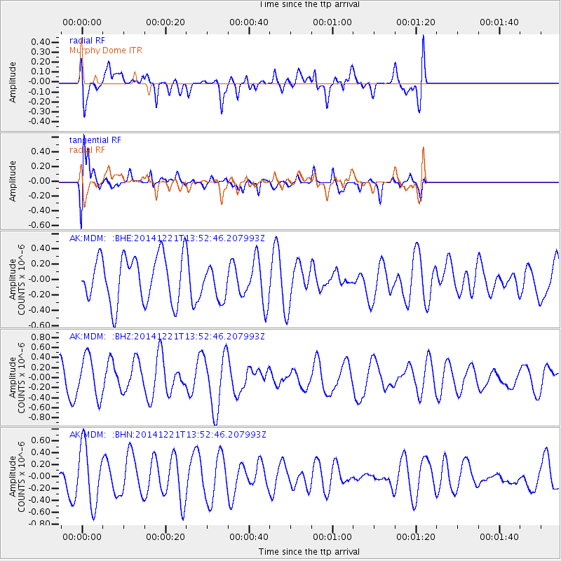
MDM Murphy Dome - Earthquake Result Viewer
*The percent match for this event was below the threshold and hence no stack was calculated.
| Earthquake location: |
Northern Molucca Sea |
| Earthquake latitude/longitude: |
2.1/126.6 |
| Earthquake time(UTC): |
2014/12/21 (355) 13:40:41 GMT |
| Earthquake Depth: |
48 km |
| Earthquake Magnitude: |
5.5 MW, 5.2 mb |
| Earthquake Catalog/Contributor: |
ISC/ISC |
|
| Network: |
AK Alaska Regional Network |
| Station: |
MDM Murphy Dome |
| Lat/Lon: |
64.96 N/148.23 W |
| Elevation: |
634 m |
|
| Distance: |
86.1 deg |
| Az: |
25.156 deg |
| Baz: |
266.518 deg |
| Ray Param: |
$rayparam |
*The percent match for this event was below the threshold and hence was not used in the summary stack. |
|
| Radial Match: |
51.516407 % |
| Radial Bump: |
400 |
| Transverse Match: |
72.44285 % |
| Transverse Bump: |
400 |
| SOD ConfigId: |
3390531 |
| Insert Time: |
2019-04-15 17:36:18.223 +0000 |
| GWidth: |
2.5 |
| Max Bumps: |
400 |
| Tol: |
0.001 |
|
Signal To Noise
| Channel | StoN | STA | LTA |
| AK:MDM: :BHZ:20141221T13:52:46.207993Z | 1.5229437 | 4.11889E-7 | 2.7045584E-7 |
| AK:MDM: :BHN:20141221T13:52:46.207993Z | 2.551303 | 4.9721166E-7 | 1.9488539E-7 |
| AK:MDM: :BHE:20141221T13:52:46.207993Z | 0.70417726 | 2.138722E-7 | 3.0371928E-7 |
| Arrivals |
| Ps | |
| PpPs | |
| PsPs/PpSs | |


