You are here: Home > Network List > US - United States National Seismic Network Stations List
> Station AMTX Amarillo, Texas, USA > Earthquake Result Viewer
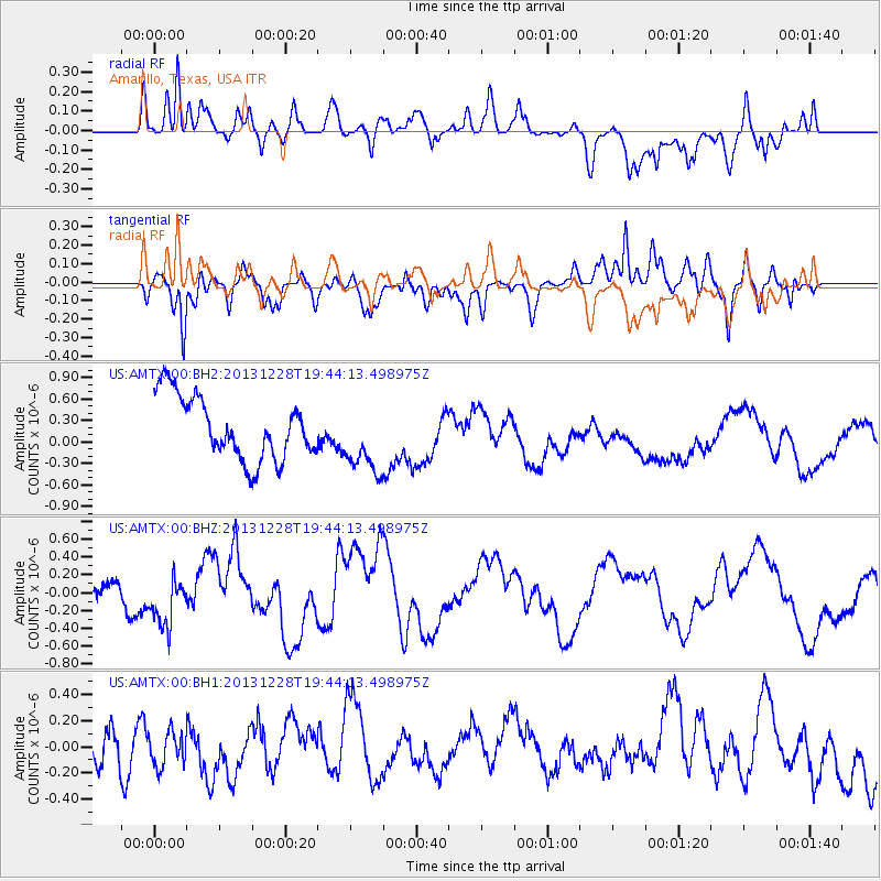
AMTX Amarillo, Texas, USA - Earthquake Result Viewer
*The percent match for this event was below the threshold and hence no stack was calculated.
| Earthquake location: |
Mariana Islands Region |
| Earthquake latitude/longitude: |
20.8/146.7 |
| Earthquake time(UTC): |
2013/12/28 (362) 19:31:23 GMT |
| Earthquake Depth: |
12 km |
| Earthquake Magnitude: |
5.6 MWC, 5.6 MWC |
| Earthquake Catalog/Contributor: |
NEIC PDE/NEIC COMCAT |
|
| Network: |
US United States National Seismic Network |
| Station: |
AMTX Amarillo, Texas, USA |
| Lat/Lon: |
34.53 N/101.41 W |
| Elevation: |
1010 m |
|
| Distance: |
95.1 deg |
| Az: |
50.263 deg |
| Baz: |
299.342 deg |
| Ray Param: |
$rayparam |
*The percent match for this event was below the threshold and hence was not used in the summary stack. |
|
| Radial Match: |
66.700226 % |
| Radial Bump: |
400 |
| Transverse Match: |
55.73207 % |
| Transverse Bump: |
400 |
| SOD ConfigId: |
626651 |
| Insert Time: |
2014-04-20 05:24:32.877 +0000 |
| GWidth: |
2.5 |
| Max Bumps: |
400 |
| Tol: |
0.001 |
|
Signal To Noise
| Channel | StoN | STA | LTA |
| US:AMTX:00:BHZ:20131228T19:44:13.498975Z | 1.2631242 | 2.8131132E-7 | 2.2271074E-7 |
| US:AMTX:00:BH1:20131228T19:44:13.498975Z | 0.5708705 | 1.3435663E-7 | 2.3535394E-7 |
| US:AMTX:00:BH2:20131228T19:44:13.498975Z | 1.2439811 | 4.969672E-7 | 3.9949737E-7 |
| Arrivals |
| Ps | |
| PpPs | |
| PsPs/PpSs | |


