You are here: Home > Network List > US - United States National Seismic Network Stations List
> Station NEW Newport, Washington, USA > Earthquake Result Viewer
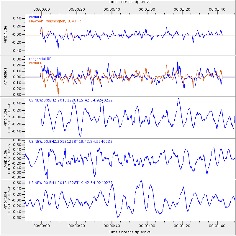
NEW Newport, Washington, USA - Earthquake Result Viewer
*The percent match for this event was below the threshold and hence no stack was calculated.
| Earthquake location: |
Mariana Islands Region |
| Earthquake latitude/longitude: |
20.8/146.7 |
| Earthquake time(UTC): |
2013/12/28 (362) 19:31:23 GMT |
| Earthquake Depth: |
12 km |
| Earthquake Magnitude: |
5.6 MWC, 5.6 MWC |
| Earthquake Catalog/Contributor: |
NEIC PDE/NEIC COMCAT |
|
| Network: |
US United States National Seismic Network |
| Station: |
NEW Newport, Washington, USA |
| Lat/Lon: |
48.26 N/117.12 W |
| Elevation: |
760 m |
|
| Distance: |
78.8 deg |
| Az: |
42.625 deg |
| Baz: |
288.47 deg |
| Ray Param: |
$rayparam |
*The percent match for this event was below the threshold and hence was not used in the summary stack. |
|
| Radial Match: |
59.09187 % |
| Radial Bump: |
400 |
| Transverse Match: |
61.143703 % |
| Transverse Bump: |
400 |
| SOD ConfigId: |
626651 |
| Insert Time: |
2014-04-20 05:24:55.740 +0000 |
| GWidth: |
2.5 |
| Max Bumps: |
400 |
| Tol: |
0.001 |
|
Signal To Noise
| Channel | StoN | STA | LTA |
| US:NEW:00:BHZ:20131228T19:42:54.924023Z | 1.5881629 | 4.4810858E-7 | 2.821553E-7 |
| US:NEW:00:BH1:20131228T19:42:54.924023Z | 1.507717 | 2.3525642E-7 | 1.5603487E-7 |
| US:NEW:00:BH2:20131228T19:42:54.924023Z | 0.9314927 | 2.3668414E-7 | 2.5409125E-7 |
| Arrivals |
| Ps | |
| PpPs | |
| PsPs/PpSs | |


