You are here: Home > Network List > IU - Global Seismograph Network (GSN - IRIS/USGS) Stations List
> Station SLBS Sierra la Laguna Baja California Sur, Mexico > Earthquake Result Viewer
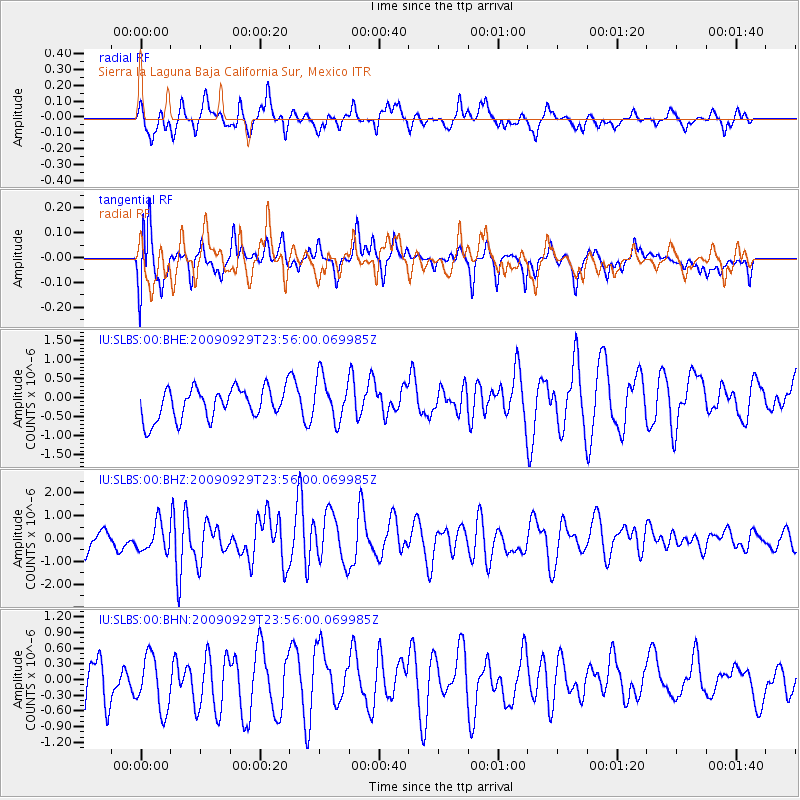
SLBS Sierra la Laguna Baja California Sur, Mexico - Earthquake Result Viewer
*The percent match for this event was below the threshold and hence no stack was calculated.
| Earthquake location: |
Samoa Islands Region |
| Earthquake latitude/longitude: |
-15.8/-172.6 |
| Earthquake time(UTC): |
2009/09/29 (272) 23:45:03 GMT |
| Earthquake Depth: |
10 km |
| Earthquake Magnitude: |
6.0 MB, 5.8 MS |
| Earthquake Catalog/Contributor: |
WHDF/NEIC |
|
| Network: |
IU Global Seismograph Network (GSN - IRIS/USGS) |
| Station: |
SLBS Sierra la Laguna Baja California Sur, Mexico |
| Lat/Lon: |
23.69 N/109.94 W |
| Elevation: |
825 m |
|
| Distance: |
72.7 deg |
| Az: |
58.497 deg |
| Baz: |
243.534 deg |
| Ray Param: |
$rayparam |
*The percent match for this event was below the threshold and hence was not used in the summary stack. |
|
| Radial Match: |
60.61666 % |
| Radial Bump: |
366 |
| Transverse Match: |
63.890263 % |
| Transverse Bump: |
400 |
| SOD ConfigId: |
1 |
| Insert Time: |
2010-02-19 00:23:32.158 +0000 |
| GWidth: |
2.5 |
| Max Bumps: |
400 |
| Tol: |
0.001 |
|
Signal To Noise
| Channel | StoN | STA | LTA |
| IU:SLBS:00:BHZ:20090929T23:56:00.069985Z | 1.1985154 | 6.390528E-7 | 5.3320366E-7 |
| IU:SLBS:00:BHN:20090929T23:56:00.069985Z | 1.3115356 | 5.3934E-7 | 4.112279E-7 |
| IU:SLBS:00:BHE:20090929T23:56:00.069985Z | 1.4088937 | 5.711167E-7 | 4.0536537E-7 |
| Arrivals |
| Ps | |
| PpPs | |
| PsPs/PpSs | |


