You are here: Home > Network List > IU - Global Seismograph Network (GSN - IRIS/USGS) Stations List
> Station PMG Port Moresby, New Guinea > Earthquake Result Viewer
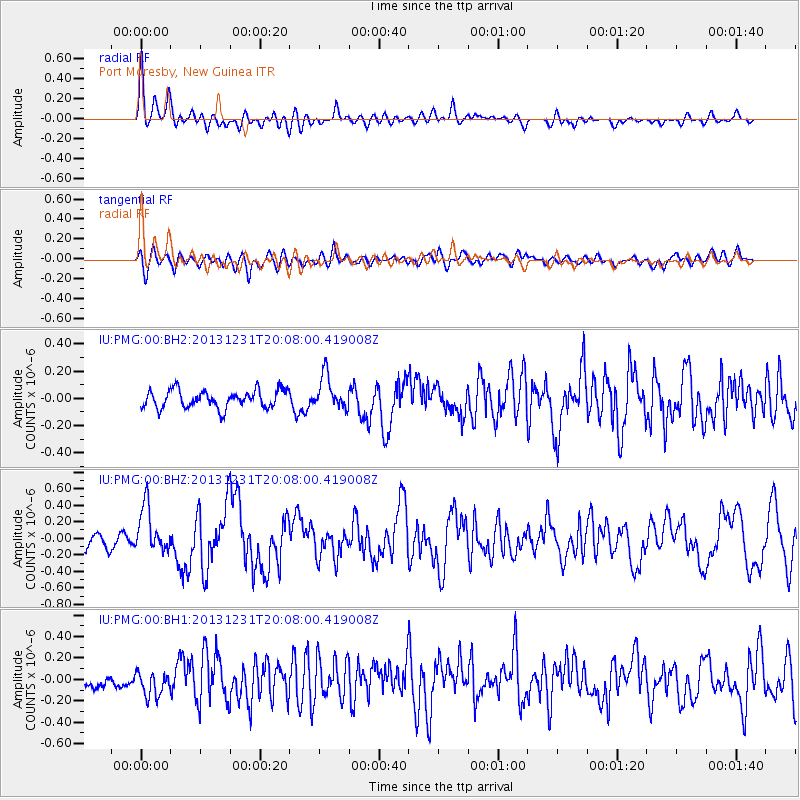
PMG Port Moresby, New Guinea - Earthquake Result Viewer
*The percent match for this event was below the threshold and hence no stack was calculated.
| Earthquake location: |
Philippine Islands Region |
| Earthquake latitude/longitude: |
19.1/120.3 |
| Earthquake time(UTC): |
2013/12/31 (365) 20:01:06 GMT |
| Earthquake Depth: |
11 km |
| Earthquake Magnitude: |
5.7 MWW, 5.7 MWC, 5.7 MWB |
| Earthquake Catalog/Contributor: |
NEIC PDE/NEIC COMCAT |
|
| Network: |
IU Global Seismograph Network (GSN - IRIS/USGS) |
| Station: |
PMG Port Moresby, New Guinea |
| Lat/Lon: |
9.40 S/147.16 E |
| Elevation: |
90 m |
|
| Distance: |
38.8 deg |
| Az: |
134.597 deg |
| Baz: |
316.974 deg |
| Ray Param: |
$rayparam |
*The percent match for this event was below the threshold and hence was not used in the summary stack. |
|
| Radial Match: |
78.57539 % |
| Radial Bump: |
400 |
| Transverse Match: |
68.18757 % |
| Transverse Bump: |
400 |
| SOD ConfigId: |
626651 |
| Insert Time: |
2014-04-20 05:56:08.472 +0000 |
| GWidth: |
2.5 |
| Max Bumps: |
400 |
| Tol: |
0.001 |
|
Signal To Noise
| Channel | StoN | STA | LTA |
| IU:PMG:00:BHZ:20131231T20:08:00.419008Z | 2.944124 | 2.7809494E-7 | 9.445762E-8 |
| IU:PMG:00:BH1:20131231T20:08:00.419008Z | 1.3907776 | 1.3666728E-7 | 9.826681E-8 |
| IU:PMG:00:BH2:20131231T20:08:00.419008Z | 1.8624895 | 1.2206947E-7 | 6.554102E-8 |
| Arrivals |
| Ps | |
| PpPs | |
| PsPs/PpSs | |


