You are here: Home > Network List > US - United States National Seismic Network Stations List
> Station NEW Newport, Washington, USA > Earthquake Result Viewer
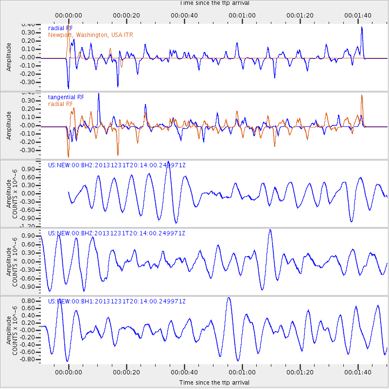
NEW Newport, Washington, USA - Earthquake Result Viewer
*The percent match for this event was below the threshold and hence no stack was calculated.
| Earthquake location: |
Philippine Islands Region |
| Earthquake latitude/longitude: |
19.1/120.3 |
| Earthquake time(UTC): |
2013/12/31 (365) 20:01:06 GMT |
| Earthquake Depth: |
11 km |
| Earthquake Magnitude: |
5.7 MWW, 5.7 MWC, 5.7 MWB |
| Earthquake Catalog/Contributor: |
NEIC PDE/NEIC COMCAT |
|
| Network: |
US United States National Seismic Network |
| Station: |
NEW Newport, Washington, USA |
| Lat/Lon: |
48.26 N/117.12 W |
| Elevation: |
760 m |
|
| Distance: |
95.6 deg |
| Az: |
34.445 deg |
| Baz: |
306.836 deg |
| Ray Param: |
$rayparam |
*The percent match for this event was below the threshold and hence was not used in the summary stack. |
|
| Radial Match: |
64.20032 % |
| Radial Bump: |
400 |
| Transverse Match: |
63.361904 % |
| Transverse Bump: |
298 |
| SOD ConfigId: |
626651 |
| Insert Time: |
2014-04-20 06:00:06.287 +0000 |
| GWidth: |
2.5 |
| Max Bumps: |
400 |
| Tol: |
0.001 |
|
Signal To Noise
| Channel | StoN | STA | LTA |
| US:NEW:00:BHZ:20131231T20:14:00.249971Z | 0.78420347 | 5.477782E-7 | 6.9851535E-7 |
| US:NEW:00:BH1:20131231T20:14:00.249971Z | 2.162518 | 4.8631733E-7 | 2.2488474E-7 |
| US:NEW:00:BH2:20131231T20:14:00.249971Z | 1.8009027 | 7.087763E-7 | 3.9356723E-7 |
| Arrivals |
| Ps | |
| PpPs | |
| PsPs/PpSs | |


