You are here: Home > Network List > G - GEOSCOPE Stations List
> Station INU Inuyama, Japan > Earthquake Result Viewer
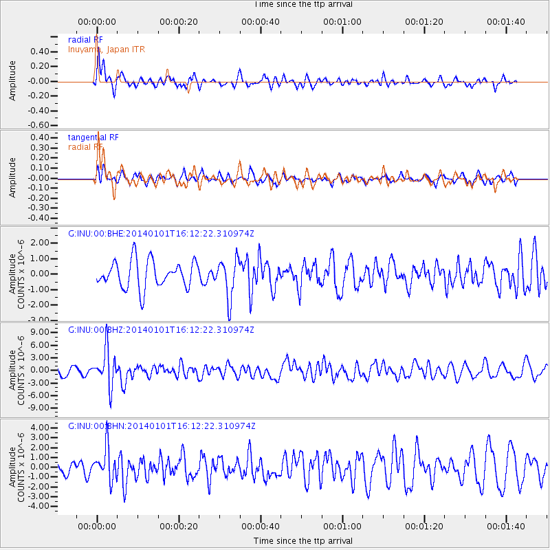
INU Inuyama, Japan - Earthquake Result Viewer
*The percent match for this event was below the threshold and hence no stack was calculated.
| Earthquake location: |
Vanuatu Islands |
| Earthquake latitude/longitude: |
-13.9/167.2 |
| Earthquake time(UTC): |
2014/01/01 (001) 16:03:29 GMT |
| Earthquake Depth: |
187 km |
| Earthquake Magnitude: |
6.5 MWW, 6.5 MWC, 6.6 MWC, 6.6 MI, 6.6 MWB |
| Earthquake Catalog/Contributor: |
NEIC PDE/NEIC COMCAT |
|
| Network: |
G GEOSCOPE |
| Station: |
INU Inuyama, Japan |
| Lat/Lon: |
35.35 N/137.03 E |
| Elevation: |
132 m |
|
| Distance: |
56.7 deg |
| Az: |
330.513 deg |
| Baz: |
144.209 deg |
| Ray Param: |
$rayparam |
*The percent match for this event was below the threshold and hence was not used in the summary stack. |
|
| Radial Match: |
66.10472 % |
| Radial Bump: |
400 |
| Transverse Match: |
54.92386 % |
| Transverse Bump: |
400 |
| SOD ConfigId: |
626651 |
| Insert Time: |
2014-04-20 06:10:39.731 +0000 |
| GWidth: |
2.5 |
| Max Bumps: |
400 |
| Tol: |
0.001 |
|
Signal To Noise
| Channel | StoN | STA | LTA |
| G:INU:00:BHZ:20140101T16:12:22.310974Z | 2.7951386 | 4.4796966E-6 | 1.6026743E-6 |
| G:INU:00:BHN:20140101T16:12:22.310974Z | 1.6422216 | 1.7174533E-6 | 1.045811E-6 |
| G:INU:00:BHE:20140101T16:12:22.310974Z | 1.4791012 | 1.2947752E-6 | 8.7537967E-7 |
| Arrivals |
| Ps | |
| PpPs | |
| PsPs/PpSs | |


