You are here: Home > Network List > TA - USArray Transportable Network (new EarthScope stations) Stations List
> Station C06D Leavenworth, WQ, USA > Earthquake Result Viewer
C06D Leavenworth, WQ, USA - Earthquake Result Viewer
| Earthquake location: |
Vanuatu Islands |
| Earthquake latitude/longitude: |
-13.9/167.2 |
| Earthquake time(UTC): |
2014/01/01 (001) 16:03:29 GMT |
| Earthquake Depth: |
187 km |
| Earthquake Magnitude: |
6.5 MWW, 6.5 MWC, 6.6 MWC, 6.6 MI, 6.6 MWB |
| Earthquake Catalog/Contributor: |
NEIC PDE/NEIC COMCAT |
|
| Network: |
TA USArray Transportable Network (new EarthScope stations) |
| Station: |
C06D Leavenworth, WQ, USA |
| Lat/Lon: |
47.92 N/120.89 W |
| Elevation: |
544 m |
|
| Distance: |
88.4 deg |
| Az: |
39.747 deg |
| Baz: |
247.413 deg |
| Ray Param: |
0.042157784 |
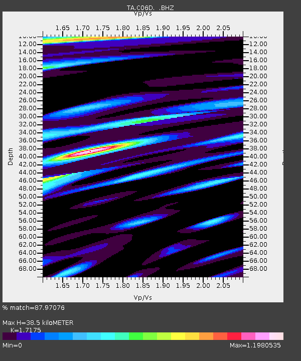
| Estimated Moho Depth: |
38.5 km |
| Estimated Crust Vp/Vs: |
1.72 |
| Assumed Crust Vp: |
6.597 km/s |
| Estimated Crust Vs: |
3.841 km/s |
| Estimated Crust Poisson's Ratio: |
0.24 |
|
| Radial Match: |
87.97076 % |
| Radial Bump: |
400 |
| Transverse Match: |
71.31881 % |
| Transverse Bump: |
400 |
| SOD ConfigId: |
626651 |
| Insert Time: |
2014-04-20 06:17:32.761 +0000 |
| GWidth: |
2.5 |
| Max Bumps: |
400 |
| Tol: |
0.001 |
|
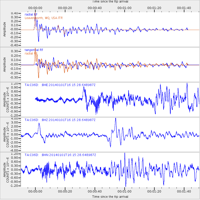
Signal To Noise
| Channel | StoN | STA | LTA |
| TA:C06D: :BHZ:20140101T16:15:28.648987Z | 6.429359 | 1.2280425E-6 | 1.9100543E-7 |
| TA:C06D: :BHN:20140101T16:15:28.648987Z | 0.9346615 | 1.8716602E-7 | 2.0025006E-7 |
| TA:C06D: :BHE:20140101T16:15:28.648987Z | 4.939747 | 4.4549833E-7 | 9.018647E-8 |
| Arrivals |
| Ps | 4.3 SECOND |
| PpPs | 15 SECOND |
| PsPs/PpSs | 20 SECOND |


