You are here: Home > Network List > TA - USArray Transportable Network (new EarthScope stations) Stations List
> Station J01E Myrtle Point, OR, USA > Earthquake Result Viewer
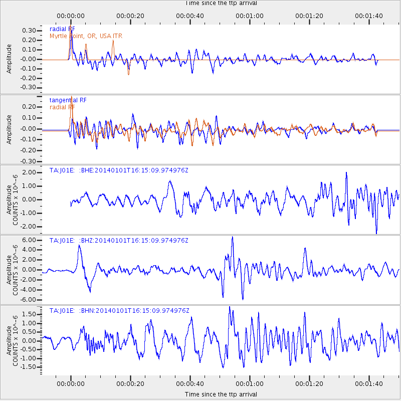
J01E Myrtle Point, OR, USA - Earthquake Result Viewer
*The percent match for this event was below the threshold and hence no stack was calculated.
| Earthquake location: |
Vanuatu Islands |
| Earthquake latitude/longitude: |
-13.9/167.2 |
| Earthquake time(UTC): |
2014/01/01 (001) 16:03:29 GMT |
| Earthquake Depth: |
187 km |
| Earthquake Magnitude: |
6.5 MWW, 6.5 MWC, 6.6 MWC, 6.6 MI, 6.6 MWB |
| Earthquake Catalog/Contributor: |
NEIC PDE/NEIC COMCAT |
|
| Network: |
TA USArray Transportable Network (new EarthScope stations) |
| Station: |
J01E Myrtle Point, OR, USA |
| Lat/Lon: |
43.16 N/123.93 W |
| Elevation: |
128 m |
|
| Distance: |
84.6 deg |
| Az: |
43.263 deg |
| Baz: |
245.464 deg |
| Ray Param: |
$rayparam |
*The percent match for this event was below the threshold and hence was not used in the summary stack. |
|
| Radial Match: |
73.92557 % |
| Radial Bump: |
400 |
| Transverse Match: |
68.78372 % |
| Transverse Bump: |
400 |
| SOD ConfigId: |
626651 |
| Insert Time: |
2014-04-20 06:18:20.381 +0000 |
| GWidth: |
2.5 |
| Max Bumps: |
400 |
| Tol: |
0.001 |
|
Signal To Noise
| Channel | StoN | STA | LTA |
| TA:J01E: :BHZ:20140101T16:15:09.974976Z | 5.952893 | 2.1090689E-6 | 3.542931E-7 |
| TA:J01E: :BHN:20140101T16:15:09.974976Z | 1.2777485 | 4.0279002E-7 | 3.152342E-7 |
| TA:J01E: :BHE:20140101T16:15:09.974976Z | 2.8931277 | 7.779352E-7 | 2.6889072E-7 |
| Arrivals |
| Ps | |
| PpPs | |
| PsPs/PpSs | |


