You are here: Home > Network List > TA - USArray Transportable Network (new EarthScope stations) Stations List
> Station K04D Chiloquin, OR, USA > Earthquake Result Viewer
K04D Chiloquin, OR, USA - Earthquake Result Viewer
| Earthquake location: |
Vanuatu Islands |
| Earthquake latitude/longitude: |
-13.9/167.2 |
| Earthquake time(UTC): |
2014/01/01 (001) 16:03:29 GMT |
| Earthquake Depth: |
187 km |
| Earthquake Magnitude: |
6.5 MWW, 6.5 MWC, 6.6 MWC, 6.6 MI, 6.6 MWB |
| Earthquake Catalog/Contributor: |
NEIC PDE/NEIC COMCAT |
|
| Network: |
TA USArray Transportable Network (new EarthScope stations) |
| Station: |
K04D Chiloquin, OR, USA |
| Lat/Lon: |
42.62 N/121.75 W |
| Elevation: |
1315 m |
|
| Distance: |
85.8 deg |
| Az: |
44.403 deg |
| Baz: |
247.037 deg |
| Ray Param: |
0.044055287 |
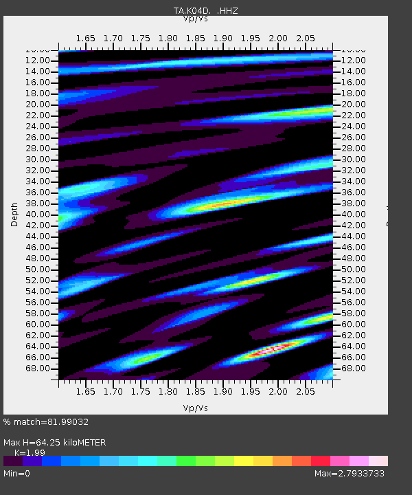
| Estimated Moho Depth: |
64.25 km |
| Estimated Crust Vp/Vs: |
1.99 |
| Assumed Crust Vp: |
6.597 km/s |
| Estimated Crust Vs: |
3.315 km/s |
| Estimated Crust Poisson's Ratio: |
0.33 |
|
| Radial Match: |
81.99032 % |
| Radial Bump: |
400 |
| Transverse Match: |
75.13995 % |
| Transverse Bump: |
400 |
| SOD ConfigId: |
626651 |
| Insert Time: |
2014-04-20 06:18:31.487 +0000 |
| GWidth: |
2.5 |
| Max Bumps: |
400 |
| Tol: |
0.001 |
|

Signal To Noise
| Channel | StoN | STA | LTA |
| TA:K04D: :HHZ:20140101T16:15:16.150024Z | 8.333523 | 2.2515198E-6 | 2.7017626E-7 |
| TA:K04D: :HHN:20140101T16:15:16.150024Z | 1.5632505 | 4.903818E-7 | 3.1369368E-7 |
| TA:K04D: :HHE:20140101T16:15:16.150024Z | 2.0954225 | 7.474976E-7 | 3.567288E-7 |
| Arrivals |
| Ps | 9.9 SECOND |
| PpPs | 28 SECOND |
| PsPs/PpSs | 38 SECOND |


